Wednesday, November 30, 2011

UK space radar project initiated


The UK government is to kick-start an innovative project to fly radar satellites around the Earth, with an initial investment of £21m.

Radar spacecraft can see the planet's surface in all weathers, day and night.It is hoped that a series of satellites could eventually be launched, enabling any place on Earth to be imaged inside 24 hours - a powerful capability.

The radar money is part of a £200m boost for science announced by the Chancellor in his Autumn Statement.George Osborne's investment will be matched by industry.

Radar is one of the most useful tools in Earth observation because of its ability to track objects and events on the ground even when there is thick cloud.

The project being backed by government has been developed by Surrey Satellite Technology Limited (SSTL), which specialises in building small, low-cost spacecraft, and its parent company, Astrium, which makes some of the biggest satellites in orbit today.

Engineers at the two firms have produced a compact radar platform they believe could win many overseas orders, and are keen to demonstrate its capabilities in space.

The new S-band radar satellite is called NovaSar-S ("Sar" stands for synthetic aperture radar). It is a 3m-by-1m spacecraft with a plank-like appearance, weighing just shy of 400kg.

Engineers have found a way to make it considerably smaller than most radar platforms in operation today, and with a price tag that would also be a fraction of that charged for bigger radar satellites.

SSTL says it can build, launch and insure a NovaSar-S for a customer for about £45m.

Mr Osborne's investment, together with SSTL's and Astrium's own money, will enable the first NovaSar-S to be put in orbit. It will be ready for launch in two to three years' time.

Assuming this pathfinder meets its design performance and begins to earn money from the sale of its imagery, SSTL plans to launch further spacecraft, to create a constellation in the sky.

Prof Sir Martin Sweeting is the executive chairman of SSTL. He told BBC News: "We're hoping we can use this commitment from the UK government to go out to our international customers, who we know have had an interest in radar for a long time, and get them to participate in the first mission, to start with, but then to take up one or two of the other satellites so that we can build a constellation in orbit."

A NovaSar-S will produce what are termed medium-resolution images, meaning details on the ground larger than 6m across would be discernable.

Monday, November 28, 2011

NASA Launches Super-Size Mars Rover to Red Planet


CAPE CANAVERAL, Fla. – The world's biggest extraterrestrial explorer, NASA's Curiosity rover, rocketed toward Mars on Saturday on a search for evidence that the red planet might once have been home to itsy-bitsy life.

It will take 8 1/2 months for Curiosity to reach Mars following a journey of 354 million miles.

An unmanned Atlas V rocket hoisted the rover, officially known as Mars Science Laboratory, into a cloudy late morning sky. A Mars frenzy gripped the launch site, with more than 13,000 guests jamming the space center for NASA's first launch to Earth's next-door neighbor in four years, and the first send-off of a Martian rover in eight years.

NASA astrobiologist Pan Conrad, whose carbon compound-seeking instrument is on the rover, had a shirt custom made for the occasion. Her bright blue, short-sleeve blouse was emblazoned with rockets, planets and the words, "Next stop Mars!"

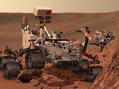
The 1-ton Curiosity -- as large as a car -- is a mobile, nuclear-powered laboratory holding 10 science instruments that will sample Martian soil and rocks, and analyze them right on the spot.

There's a drill as well as a stone-zapping laser machine.

It's "really a rover on steroids," said NASA's Colleen Hartman, assistant associate administrator for science. "It's an order of magnitude more capable than anything we have ever launched to any planet in the solar system."

The primary goal of the $2.5 billion mission is to see whether cold, dry, barren Mars might have been hospitable for microbial life once upon a time -- or might even still be conducive to life now.

No actual life detectors are on board; rather, the instruments will hunt for organic compounds.

Curiosity's 7-foot arm has a jackhammer on the end to drill into the Martian red rock, and the 7-foot mast on the rover is topped with high-definition and laser cameras. No previous Martian rover has been so sophisticated or capable.

With Mars the ultimate goal for astronauts, NASA also will use Curiosity to measure radiation at the red planet. The rover also has a weather station on board that will provide temperature, wind and humidity readings; a computer software app with daily weather updates is planned.

The world has launched more than three dozen missions to the ever-alluring Mars, most like Earth than the other solar-system planets. Yet fewer than half of those quests have succeeded.

Just two weeks ago, a Russian spacecraft ended up stuck in orbit around Earth, rather than en route to the Martian moon Phobos.

"Mars really is the Bermuda Triangle of the solar system," Hartman said. "It's the death planet, and the United States of America is the only nation in the world that has ever landed and driven robotic explorers on the surface of Mars, and now we're set to do it again."

Curiosity's arrival next August will be particularly hair-raising.

In a spacecraft first, the rover will be lowered onto the Martian surface via a jet pack and tether system similar to the sky cranes used to lower heavy equipment into remote areas on Earth.

Curiosity is too heavy to use air bags like its much smaller predecessors, Spirit and Opportunity, did in 2004. Besides, this new way should provide for a more accurate landing.

Thursday, November 24, 2011

Mars Science Laboratory Launch Milestones


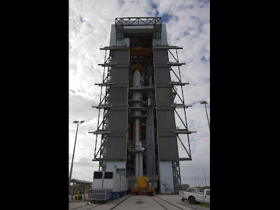
PASADENA, Calif. -- NASA's Mars Science Laboratory is tucked inside its Atlas V rocket, ready for launch on Saturday, Nov. 26, 2011 from Cape Canaveral Air Force Station in Florida. The Nov. 26 launch window extends from 7:02 a.m. to 8:45 a.m. PST (10:02 a.m. to 11:45 a.m. EST). The launch period for the mission extends through Dec. 18.

The spacecraft, which will arrive at Mars in August 2012, is equipped with the most advanced rover ever to land on another planet. Named Curiosity, the rover will investigate whether the landing region has had environmental conditions favorable for supporting microbial life, and favorable for preserving clues about whether life existed.

On Nov. 26, NASA Television coverage of the launch will begin at 4:30 a.m. PST (7:30 a.m. EST). Live launch coverage will be carried on all NASA Television channels.

If the spacecraft lifts off at the start of the launch window on Nov. 26, the following milestones are anticipated. Times would vary for other launch times and dates.

Launch
The rocket's first-stage common core booster, and the four solid rocket boosters, will ignite before liftoff. Launch, or "T Zero", actually occurs before the rocket leaves the ground. The four solid rocket boosters jettison at launch plus one minute and 52 seconds.

Fairing Separation
The nose cone, or fairing, carrying Mars Science Laboratory will open like a clamshell and fall away at about three minutes and 25 seconds after launch. After this, the rocket's first stage will cut off and then drop into the Atlantic Ocean.

Parking Orbit
The rocket's second stage, a Centaur engine, is started for the first time at about four minutes and 38 seconds after launch. After it completes its first burn of about 7 minutes, the rocket will be in a parking orbit around Earth at an altitude that varies from 102 miles (165 kilometers) to 201 miles (324 kilometers). It will remain there from 14 to 30 minutes, depending on the launch date and time. If launch occurs at the beginning of the launch Nov. 26 launch window, this stage will last about 21 minutes.

On the Way to Mars
The second Centaur burn, continuing for nearly 8 minutes (for a launch at the opening of the Nov. 26 launch window), lofts the spacecraft out of Earth orbit and sends it toward Mars.

Tuesday, November 22, 2011

Using Satellites to Help the Earth Sustain Seven Billion People


With seven billion people now living on Earth, the expanding demand for resources is exerting unprecedented pressure on global resources, especially forests, water and food. NASA and the U.S. Geological Survey are using satellite technology to monitor the changing resources.

Every three seconds, the world loses a football-field sized swath of forest. As forests are cut for fuel or burned to allow the planting of crops, the Earth loses the ability of forests to capture carbon from the atmosphere or to support biodiversity with an untold loss of plant and animal species.

The fate of world forests is just one concern linked to population growth. With the United Nations (U.N.) declaring that seven billion people now live on our planet, the question becomes: How can Earth resources be managed best to support so many?

"Feeding the people of the world requires not only land for agriculture, but it also requires fresh water and energy," said James Irons, Landsat project scientist at NASA's Goddard Space Flight Center in Greenbelt, Md.

About half of the seven billion were added in the past 40 years and although birth rates in many countries are stabilizing, the U.N. estimates that three billion more people are expected by 2100.

This expanding demand will exert unprecedented pressure on global natural resources, Irons said, especially forests, water and agriculture. To support a world population expected to reach eight billion as soon as 2025, these crucial resources need to be closely monitored and sustained.

"What we've done with satellites over the past 40 years is to revolutionize how we monitor agriculture, forests, fresh water consumption and other Earth resources required by the global population," Irons said, adding that the worldwide pressure of feeding everyone requires a tool that has a whole-world view, making satellites a unique resource for scientists and policy makers alike.

The Landsat Program is a series of Earth-observing satellite missions jointly managed by NASA and the U.S. Geological Survey. Since 1972, the Landsat Earth observation satellites have monitored changes at the Earth's land surface, including changes in forests, water bodies and agricultural and urban areas.

"For example, it's only by viewing Landsat data that we would know how quickly the world's forests are being destroyed," said Alan Belward, of the European Commission Joint Research Centre. "More than 80 percent of the rural population in Africa relies exclusively on forests and woodland for all their energy needs."

Belward joins NASA's James Irons and other experts in mapping and monitoring our planet to describe present conditions and outline the future of many of Earth's natural resources at a noon press conference at the Pecora Remote Sensing Symposium, held Wednesday, November 16, 2011 in Herndon, Va.

Belward says that verifying how many countries manage their forest data has historically been a challenge.

"But with open and freely available scientific data, anyone and everyone can track these resources and see how they're being used or abused," Belward said.

"Different countries manage their forests, their property rights laws and their conservation efforts differently," he added, "making it important that precise scientific assessments are widely distributed and freely available to everyone in the research and public policy community."

In addition to forests, satellite data provide a 'big picture' view that includes an exquisite level of detail on crops being planted worldwide. For example, the United States Department of Agriculture uses satellite data extensively to help determine where, when and which crops are planted each year and to predict production and make commodity forecasts.

Precise observations of irrigated agriculture taken year after year by the Landsat series of satellites, for example, clearly show how fresh water consumption varies annually and spatially across the landscape.

Monday, November 21, 2011

NASA's TRMM satellite sees deadly tornadic thunderstorms in Southeastern US


Tornadoes are expected to accompany severe storms in the springtime in the U.S., but this time of year they also usually happen. When a line of severe thunderstorms associated with a cold front swept through the U.S. southeast on Nov. 16, TRMM collected rainfall data on the dangerous storms from space. NASA's Tropical Rainfall Measuring Mission (TRMM) satellite flew over the southeastern United States on November 16, 2011 at 2310 UTC (6:10 p.m. EST) when tornadoes were occurring with a line of thunderstorms that stretched from western Florida north through North Carolina. At least six deaths were caused by one of these tornadoes that destroyed three homes near Rock Hill, South Carolina.

Typically in the fall, the transition from warm air to cooler air occurs as Canadian cold air moves down into the U.S. The combination of a strong cold front with warm, moist air in its path enables the creation of strong to severe storms at this time of year.

TRMM data was used to create a rainfall analysis of the line of severe thunderstorms associated with the cold front. The analysis showed that the area of moderate to very heavy rainfall (falling at more than 2 inches or 50 mm per hour) with this frontal system was only located in a narrow line. In addition to heavy rain and some tornadoes, the strong cold front brought winds gusting over 30 mph, and a temperature drop of as much as 20 degrees as the front passed.

TRMM rainfall imagery is created at the NASA Goddard Space Flight Center in Greenbelt, Md. To create the images, rain rates in the center swaths are taken from the TRMM Precipitation Radar (PR), a unique space-borne precipitation radar, while rain rates in the outer swath are from the TRMM Microwave Imager (TMI). The rain rates are overlaid on infrared (IR) data from the TRMM Visible Infrared Scanner (VIRS) to form a complete picture of the rainfall in a storm or storm system like this one.

Thursday, November 17, 2011

Mobile Launcher Moves to Launch Pad


The mobile launcher is making the longest trip of its young life today to begin a two-week series of structural tests at Launch Pad 39B at NASA's Kennedy Space Center in Florida.

In anticipation of launching the Space Launch System later this decade, engineers wanted to check the mobile launcher, or ML, in a number of categories ranging from how it would behave moving atop a crawler-transporter to how well its systems mesh with the infrastructure at Pad B, which has undergone extensive renovations during the past year.

"We have the time and will be able to gain significant knowledge that will assist in the development of the ML," said Larry Schultz, ML project manager.

The ML began its 14-hour move at 9:15 a.m. on Nov. 16. The trip will cover about 4.2 miles from a work site beside the Vehicle Assembly Building to the launch pad.

Schultz said the team will get its first look at the information after the move is complete.

Rising 400 feet above the rocky crawlerway, the mobile launcher is substantially different than the mobile launcher platforms that carried space shuttles to the launch pads for 30 years. The dominant feature is the ML's tower, a 355-foot-high gray, steel tower reminiscent of the ones that serviced the Saturn V rockets headed to the moon in the 1960s and 70s.

In fact, not since 1975 has a launch structure as tall as the ML stood at either of Kennedy's launch pads.

The ML had been moved once before, but not very far. It was repositioned at its worksite beside the Vehicle Assembly Building in October 2010.

Although it was originally envisioned to host a slim rocket, the structure's design was flexible enough that it can be modified to support the Space Launch System, or SLS, a rocket that is in the same lifting category as the Saturn V.

The modifications to come include strengthening the supports in the base and widening the exhaust port the rocket will stand over. The ML's exhaust port now is a 22-foot square. It will be made into a 60-foot-by-30-foot rectangle.

Swing arms will be added to the tower in the 2015 timeframe, modified to provide fueling and venting along with electrical and communication links to the different stages of the rocket, along with a crew access arm reaching out to NASA's new Orion spacecraft at the top of the rocket. Even with the modifications, the structure will be lighter than the shuttle's mobile launcher platform.

The tower was built atop a 47-foot-tall base of steel that is 165 feet long and 135 feet wide. Altogether, the ML weighs in at 6.75 million pounds.

Tuesday, November 15, 2011

NASA grows audience, credibility through tweetups


HAMPTON, Va. (AP) — Rocket science isn't easily explainable in 140 characters, but NASA is asking a group of people to do just that with a series of VIP tours for some of its ardent Twitter followers.

The events called tweetups offer ordinary science fans a behind-the-scenes look at the space agency's facilities that can include its astronauts and scientists. In exchange, many participants — whose day jobs range from church office worker to baker — narrate their day through tweets, photographs and videos.

NASA's imagination-grabbing work gives it a bigger pool of fans to draw from than many companies or government agencies, and it sets itself apart further with its egalitarian approach to social media. While it's not unusual for an organization to give special access to journalists or influential bloggers, experts say NASA sets itself apart by inviting people who may only have a few dozen followers.

"It goes against the grain of only talking to people that have a lot of influence," said William Ward, a social media professor at Syracuse University.

Participants are chosen through a lottery. While some end up being self-described techies who blog regularly about space, it's important to NASA that it draws people with a wide range of interests who can tweet with authentic voices to a varied audience.

"I think everybody knows if you hear it from a friend or a family member, you see it as being much more credible than it being from a government organization like NASA," said Stephanie Schierholz, NASA's social media manager.

The sentiment was echoed by a participant in a tweetup held last week at Langley Research Center in Hampton.

"I know I have friends at home who are following every word here. And they're not normally space enthusiasts, but it's just something that, 'Hey, David's going down there. Let's see what he's up to.' And they're following my photos and my tweets and they get excited, too," said David Parmet, from Westchester County, N.Y.

NASA's first tweetup was in 2009, and it's held a total of 30. Some have coincided with news events like rocket launches, and one is planned in Florida the week of Thanksgiving for the Mars rover launch. The events can last from two hours to two days, ranging from a few dozen participants to more than 100. Participants pay their own travel expenses.

While it's not clear how many new Twitter followers NASA has gained from the tweetups, the number is expanding rapidly. Since June, nearly 600,000 people have started following the agency — about 4,000 to 5,000 per day — for a total of about 1.6 million.

NASA tweetup alumni closely monitor their reach and noted that when 150 participants were invited to Kennedy Space Center in Florida this August for the Juno spacecraft launch their tweets — through the power of retweets — had 29.9 million potential views.

"This is pretty small from a resource perspective, yet it has this huge impact," Schierholz said.

The tweetup has become a prime example of how NASA is harnessing social media to keep the agency in the public's imagination in an era where its most recognizable program, the space shuttle, has come to an end.

"We know more about Kim Kardashian than we do important scientific events that are happening in our country," said Donna Hoffman, a marketing professor at the University of California at Riverside. "This is NASA's opportunity, I think, to educate a new demographic."

Schierholz said the public generally has a strong positive reaction to NASA, but is unfamiliar with a lot of its work.

That is particularly true at Langley. Among other things, the center's research has resulted in wing design that allows airplanes to use less fuel. It's currently testing whether a craft designed to send astronauts into deep space can survive falling into the Pacific Ocean.

The work is important, but it rarely generates public excitement.

"We really do live in a visual society and people want to be able to see things," said Rob Wyman, Langley's news chief. "One of our challenges here is that there's a sort of latency to the work that we do here. There's a very deliberative process that research follows that tends to take a lot more time."

Illustrating the center's lack of fame, one participant at last week's tweetup from Maine was late because he thought the center was across the state in Langley, Va., the same place that's home to the CIA. It's a common mistake.

Even for those who live near one, opportunities to visit a NASA facility are limited.

Monday, November 14, 2011

NASA Ready for November Launch of Car-Size Mars Rover


PASADENA, Calif. -- NASA's most advanced mobile robotic laboratory, which will examine one of the most intriguing areas on Mars, is in final preparations for a launch from Florida's Space Coast at 10:25 a.m. EST (7:25 a.m. PST) on Nov. 25.

The Mars Science Laboratory mission will carry Curiosity, a rover with more scientific capability than any ever sent to another planet. The rover is now sitting atop an Atlas V rocket awaiting liftoff from Cape Canaveral Air Force Station.

"Preparations are on track for launching at our first opportunity," said Pete Theisinger, Mars Science Laboratory project manager at NASA's Jet Propulsion Laboratory in Pasadena, Calif. "If weather or other factors prevent launching then, we have more opportunities through Dec. 18."

Scheduled to land on the Red Planet in August 2012, the one-ton rover will examine Gale Crater during a nearly two-year prime mission. Curiosity will land near the base of a layered mountain 3 miles (5 kilometers) high inside the crater. The rover will investigate whether environmental conditions ever have been favorable for development of microbial life and preserved evidence of those conditions.

"Gale gives us a superb opportunity to test multiple potentially habitable environments and the context to understand a very long record of early environmental evolution of the planet," said John Grotzinger, project scientist for the Mars Science Laboratory at the California Institute of Technology in Pasadena. "The portion of the crater where Curiosity will land has an alluvial fan likely formed by water-carried sediments. Layers at the base of the mountain contain clays and sulfates, both known to form in water."

Curiosity is twice as long and five times as heavy as earlier Mars rovers Spirit and Opportunity. The rover will carry a set of 10 science instruments weighing 15 times as much as its predecessors' science payloads.

A mast extending to 7 feet (2.1 meters) above ground provides height for cameras and a laser-firing instrument to study targets from a distance. Instruments on a 7-foot-long (2.1-meter-long) arm will study targets up close. Analytical instruments inside the rover will determine the composition of rock and soil samples acquired with the arm's powdering drill and scoop. Other instruments will characterize the environment, including the weather and natural radiation that will affect future human missions.

"Mars Science Laboratory builds upon the improved understanding about Mars gained from current and recent missions," said Doug McCuistion, director of the Mars Exploration Program at NASA Headquarters in Washington. "This mission advances technologies and science that will move us toward missions to return samples from, and eventually send humans to, Mars."

The mission is challenging and risky. Because Curiosity is too heavy to use an air-bag cushioned touchdown, the mission will use a new landing method, with a rocket-powered descent stage lowering the rover on a tether like a kind of sky-crane.

Tuesday, November 8, 2011

Space shuttle data leads to better model for solar power production in California


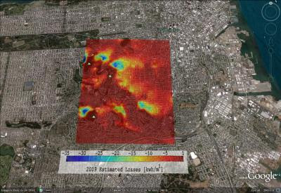
The space shuttle program may have ended, but data the space craft collected over the past three decades are still helping advance science. Researchers at the Jacobs School of Engineering at UC San Diego recently used measurements from NASA's Shuttle Radar Topography Mission to predict how changes in elevation, such as hills and valleys, and the shadows they create, impact power output in California's solar grid.

Current large-scale models used to calculate solar power output do not take elevation into account. The California Public Utilities Commission asked Jan Kleissl, a professor of environmental engineering at the Jacobs School of Engineering at UC San Diego, and postdoctoral researcher Juan Luis Bosch, from the department of mechanical and aerospace engineering, to build a model that does.

This is the first time this kind of model will be made available publicly on such a large scale, including all of Southern California, as well as the San Francisco Bay Area. It took the Triton Supercomputer at the San Diego Supercomputer Center here at UCSD 60,000 processor hours to run calculations for the model. Utility companies and homeowners can use the model to get a more realistic picture of the solar power output they can typically expect to produce. This is an especially important tool for utilities, because it gives them a better idea of how much revenue they can actually generate, Kleissl said.

Changes in elevation can have a significant impact on solar power output. The longer it takes for the sun to rise above the local horizon in the morning and the earlier it sets in the evening, the more solar fuel is lost. Solar days are longest on top of tall mountains. They are shortest in steep valleys oriented north-south, where it can take more than an hour longer for the sun to appear in the east.