Friday, October 29, 2010

Dark Reflections in the Southern Cross


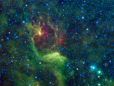
NASA's Wide-field Infrared Survey Explorer, or WISE, captured this colorful image of the reflection nebula IRAS 12116-6001. This cloud of interstellar dust cannot be seen directly in visible light, but WISE's detectors observed the nebula at infrared wavelengths.

In images of reflection nebulae taken with visible light, clouds of dust reflect the light of nearby stars. The dust is warmed to relatively cool temperatures by the starlight and glows with infrared light, which WISE can detect. Reflection nebulae are of interest to astronomers because they are often the sites of new star formation.

The bright blue star on the right side of the image is the variable star Epsilon Crucis. In the Bayer system of stellar nomenclature, stars are given names based on their relative brightness within a constellation. The Greek alphabet is used to designate the star's apparent brightness compared to other stars in the same constellation. "Alpha" is the brightest star in the constellation, "beta" the second brightest, and so on. In this case, "epsilon" is the fifth letter of the Greek alphabet, so Epsilon Crucis is the fifth brightest star in the constellation Crux.

Crux is a well-known constellation that can be easily seen by observers in the Southern Hemisphere and from low northern latitudes. Also known as the Southern Cross, Crux is featured in many country's flags, including Australia, Brazil and New Zealand (although New Zealand's flag does not include Epsilon Crucis).

The colors used in this image represent specific wavelengths of infrared light. The blue color of Epsilon Crucis represents light emitted at 3.4 and 4.6 microns. The green-colored star seen beside Epsilon Crucis is emitting light at 12 microns. This star is IRAS 12194-6007, a carbon star that is near the end of its lifecycle. Since the infrared wavelengths emitted by this star are longer than those from Epsilon Crucis, it is cooler. The green and red colors seen in the reflection nebula represent 12- and 22-micron light coming from the nebula's dust grains warmed by nearby stars.

Tuesday, October 26, 2010

[VIDEO] “Indonesia Tsunami 2010″

A major earthquake has struck off the coast of Indonesia's Sumatra island, but there are no immediate reports of damage or casualties.amage or casualties.

Earthquake off Indonesia's Aceh triggers tsunami alert

An earthquake of magnitude 7.4 has struck offshore near the Indonesian island of Sumatra, near Aceh province.

The quake struck 214km (133 miles) south of Aceh's capital of Banda Aceh, the US Geological Survey (USGS) said.

A local tsunami alert was issued and later lifted by the Pacific Tsunami Warning Center.

The site is very near that of 2004's 9.2 magnitude earthquake. About 220,000 people were killed in the Indian Ocean tsunami the quake triggered.

The epicentre of the latest quake was at a depth of 61.4km, about 66km (41 miles) south-west of Meulaboh district, the USGS said.

The district, and other parts of Aceh, were devastated in the 26 December 2004 earthquake.

Ring of Fire

The quake hit at 1259 (0559 GMT). Local media reported some houses were damaged and power lines knocked down, Associated Press news agency said.

The Pacific Tsunami Warning Center lifted its tsunami watch several hours after the earthquake.

"Sea level readings indicate that a significant tsunami was not generated," the Hawaii-based centre said in a statement on its website.

"Therefore, the tsunami watch issued by this center is now cancelled."

The USGS earlier said it believed there was no threat of a destructive, widespread tsunami but the possibility of a local tsunami existed.

Indonesia is located on the volatile Pacific Ring of Fire, a belt of tectonic activity girdling the Pacific Ocean that triggers earthquakes and volcanic activity.

Aceh is on the north-western tip of Sumatra, one of Indonesia's main islands, and is frequently rocked by earthquakes.

One last year near Padang in West Sumatra province killed more than 1,000 people.

About 170,000 people were killed in Aceh from the 2004 earthquake and the tsunami it launched.

The waves spread across the Indian Ocean to cause death and destruction as far away as Sri Lanka, Burma and Thailand.

Friday, October 22, 2010

Lunar Impact May Impact Lunar Science For Years To Come


The lunar rocks brought back to Earth by the Apollo astronauts were found to have very little water, and were much drier than rocks on Earth. An explanation for this was that the moon formed billions of years ago in the solar system's turbulent youth, when a Mars-sized planet crashed into Earth. The impact stripped away our planet's outer layer, sending it into orbit. The pieces later coalesced under their own gravity to form our moon. Heat from all this mayhem vaporized most of the water in the lunar material, so the water was lost to space.

However, there was still a chance that water might be found in special places on the moon. Due to the moon's orientation to the sun, scientists theorized that deep craters at the lunar poles would be in permanent shadow and thus extremely cold and able to trap volatile material, like water as ice perhaps delivered there by comet impacts or chemical reactions with hydrogen carried by the solar wind.

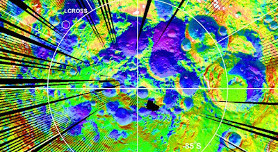
In October 9, 2009, NASA's LCROSS (Lunar Crater Remote Observation and Sensing Satellite) was intentionally crashed into the Cabeus crater near the lunar south pole. The idea was to kick up debris from the bottom of the crater so its composition could be analyzed. LCROSS hit at over 9,000 kilometers (5,600 miles) per hour, sending up a plume of material over 19 kilometers (12 miles) high.

"Seeing mostly pure water ice grains in the plume means water ice was somehow delivered or chemical processes are causing ice to accumulate in large quantities," said Anthony Colaprete, LCROSS project scientist and principal investigator at NASA's Ames Research Center, Moffett Field, Calif. "Furthermore, the diversity and abundance of certain materials called volatiles in the plume, suggest a variety of sources, like comets and asteroids, and an active water cycle within the lunar shadows."

LCROSS was a companion mission to NASA's Lunar Reconnaissance Orbiter (LRO) mission. The two missions were designed to work together, and support from LRO was critical to the success of LCROSS. During impact, LRO, which is normally looking at the lunar surface, was tilted toward the horizon so it could observe the plume. Shortly after LCROSS hit the moon, LRO flew past debris and gas from the impact while its instruments collected data.

"LRO assisted LCROSS in two primary ways - selecting the impact site and confirming the LCROSS observations," said Gordon Chin of NASA's Goddard Space Flight Center, Greenbelt, Md., LRO associate project scientist.

"Since observatories on Earth were also planning to view the LCROSS impact, there were a lot of constraints on the location - the impact plume had to rise out of the crater and into sunlight, and it had to be visible from Earth," said Chin.

"Originally, the LCROSS team was going with a site farther north than the Cabeus crater, because it was better for Earth visibility," said Chin. "However, LEND revealed that the area did not have a high hydrogen concentration, but Cabeus did. Also, Diviner showed that Cabeus was one of the coldest sites, and LOLA indicated it was in permanent shadow. So, we were able to influence the decision to aim for Cabeus farther south -- while it was a little less visible from Earth, Cabeus was ultimately better for what we were trying to find."

The Diviner instrument aboard the Lunar Reconnaissance Orbiter was built and is managed by NASA's Jet Propulsion Laboratory in Pasadena, Calif. Temperature maps from LRO's Diviner instrument were also crucial to identify where the coldest places were.

David Paige, principal investigator of the Diviner instrument from the University of California, Los Angeles, used temperature measurements of the lunar south pole obtained by Diviner to model the stability of water ice both at and near the surface.

"The temperatures inside these permanently shadowed craters are even colder than we had expected. Our model results indicate that in these extreme cold conditions, surface deposits of water ice would almost certainly be stable," said Paige, "but perhaps more significantly, these areas are surrounded by much larger permafrost regions where ice could be stable just beneath the surface."

"We conclude that large areas of the lunar south pole are cold enough to trap not only water ice, but other volatile compounds (substances with low boiling points) such as sulfur dioxide, carbon dioxide, formaldehyde, ammonia, methanol, mercury and sodium," Paige added.

A UCLA graduate student and Diviner team member, Paul Hayne, was monitoring the data in real-time as it was sent back from Diviner.

"During the flyby 90 seconds after impact, all seven of Diviner's infrared channels measured an enhanced thermal signal from the crater. The more sensitive of its two solar channels also measured the thermal signal, along with reflected sunlight from the impact plume. Two hours later, the three longest wavelength channels picked up the signal, and after four hours only one channel detected anything above the background temperature."

Scientists were able to learn two things from these measurements: first, they were able to constrain the mass of material that was ejected outwards into space from the impact crater; second, they were able to infer the initial temperature and make estimates about the effects of ice in the soil on the observed cooling behavior.

Another LRO instrument, the Lyman-Alpha Mapping Project (LAMP), used data on the gas cloud to confirm the presence of the gases molecular hydrogen, carbon monoxide and atomic mercury, along with smaller amounts of calcium and magnesium, also in gas form.

"We had hints from Apollo soils and models that the volatiles we see in the impact plume have been long collecting near the moon's polar regions," said Randy Gladstone, LAMP acting principal investigator, of Southwest Research Institute in San Antonio. "Now we have confirmation."

"The detection of mercury in the soil was the biggest surprise, especially that it's in about the same abundance as the water detected by LCROSS," said Kurt Retherford, LAMP team member, also of Southwest Research Institute.

"The observations by the suite of LRO and LCROSS instruments demonstrate the moon has a complex environment that experiences intriguing chemical processes," said Richard Vondrak, LRO project scientist at NASA Goddard. "This knowledge can open doors to new areas of research and exploration."

LCROSS launched with LRO aboard an Atlas V rocket from Cape Canaveral, Fla., on June 18, 2009.

The research was funded by NASA's Exploration Systems Missions Directorate at NASA Headquarters in Washington. LRO was built and is managed by NASA's Goddard Space Flight Center in Greenbelt, Md. LCROSS is managed by NASA's Ames Research Center, Moffett Field, Calif. LAMP was developed by the Southwest Research Institute in San Antonio, Texas; LOLA was built by NASA Goddard; LROC was provided by Arizona State University, Tempe; LEND was provided by Institute for Space Research, Moscow; The Diviner instrument was built and is managed by NASA's Jet Propulsion Laboratory in Pasadena, Calif. UCLA is the home institution of Diviner's principal investigator.

For more information on Diviner, visit: http://diviner.ucla.edu.
Tuesday, October 19, 2010

Taking On Water Resource Issues


Worldwide today, it is estimated that nearly 1.1 billion people live without access to adequate water supplies and about 2.6 billion people lack adequate water sanitation. Improved understanding of water processes at global and regional scales is essential for sustainability.

Researchers at JPL recently launched the Western Water Resource Solutions website to highlight activities that apply NASA expertise and data to water resource issues in the western United States.

One focus area for this new site is the hydrologic cycle and using global satellite observations of the Earth to improve our understanding of water processes on a regional and local level. The western United States is expected to bear the brunt of impacts to water resource availability because of changing precipitation patterns, increasing temperatures, and a growing population. California is already starting to feel the impacts and is taking action to develop new adaptive management practices to ensure a safe and reliable water supply, while maintaining healthy ecosystems throughout the state.

NASA researchers at Ames Research Center, the Jet Propulsion Laboratory, and Marshall Space Flight Center are currently working with water managers to apply NASA expertise and data to water resource issues in California. The project partners with universities, agencies and other stakeholders, to utilize information from a number of sources, including existing ground observations and models.

This project is only one of several NASA initiatives aimed at providing actionable scientific information on water quality and the water balance worldwide. These other projects include development of better estimates of snow pack, groundwater monitoring, soil moisture and evapotranspiration, water quality, and monitoring fragile levee systems.

In addition to raising awareness about current water resource challenges, the new website highlights NASA’s capability to use satellite and airborne data to help solve some of these challenges.

Learn more about the Western Water Resource Solution Group at: http://water.jpl.nasa.gov/

Friday, October 15, 2010

NASA Study of Haiti Quake Yields Surprising Results


The magnitude 7.0 earthquake that caused more than 200,000 casualties and devastated Haiti's economy in January resulted not from the Enriquillo fault, as previously believed, but from slip on multiple faults -- primarily a previously unknown, subsurface fault -- according to a study published online this week in Nature Geoscience.

In addition, because the earthquake did not involve slip near Earth's surface, the study suggests that it did not release all of the strain that has built up on faults in the area over the past two centuries, meaning that future surface-rupturing earthquakes in this region are likely.

Geophysicist Eric Fielding of NASA's Jet Propulsion Laboratory, Pasadena, Calif., along with lead author Gavin Hayes of the U.S. Geological Survey and other colleagues from USGS, the California Institute of Technology in Pasadena, the University of Texas at Austin, and Nagoya University, Japan, used a combination of seismological observations, geologic field data and satellite geodetic measurements to analyze the earthquake source. Initially the Haiti earthquake was thought to be the consequence of movement along a single fault -- the Enriquillo -- that accommodates the motion between the Caribbean and North American tectonic plates. But scientists in the field found no evidence of surface rupture on that fault.

The researchers found the pattern of surface deformation was dominated by movement on a previously unknown, subsurface thrust fault, named the Léogâne fault, which did not rupture the surface.

Fielding, who processed synthetic aperture radar interferometry data from a Japan Aerospace Exploration Agency (JAXA) satellite used in the study, said, "I was surprised when I saw the satellite data showed the Haiti earthquake must have ruptured a different fault than the major Enriquillo fault, which everybody expected was the source. Without the radar images, we might still be wondering what happened."

Fielding said NASA images acquired after the earthquake over the major fault zones of Hispaniola by the JPL-built Uninhabited Aerial Vehicle Synthetic Aperture Radar (UAVSAR) airborne instrument will give scientists much more detailed information should another large earthquake occur in the region in the future.

For more information, read the USGS news release: http://www.usgs.gov/newsroom/article.asp?ID=2612 .
To read the full study, visit: http://dx.doi.org/10.1038/ngeo977 .

For more on UAVSAR, see: http://uavsar.jpl.nasa.gov/mission_flights.html .

STS-133 Crew Begins Dress Rehearsal


At NASA's Kennedy Space Center in Florida, STS-133 Commander Steve Lindsey speaks to the media gathered at the Shuttle Landing Facility. From left are Nicole Stott, Michael Barratt, Eric Boe, Tim Kopra and Alvin Drew. The crew is gathered for a practice launch dress rehearsal called the Terminal Countdown Demonstration Test (TCDT) in preparation for the upcoming mission. TCDT provides each shuttle crew and launch team with an opportunity to participate in various simulated countdown activities, including equipment familiarization and emergency training. Space shuttle Discovery and its STS-133 crew will deliver the Permanent Multipurpose Module, packed with supplies and critical spare parts, as well as Robonaut 2, the dexterous humanoid astronaut helper, to the International Space Station. Launch is targeted for Nov. 1 at 4:40 p.m.

Monday, October 11, 2010

Cassini Catches Saturn Moons in Paintball Fight


PASADENA, Calif. – Scientists using data from NASA's Cassini spacecraft have learned that distinctive, colorful bands and splotches embellish the surfaces of Saturn's inner, mid-size moons. The reddish and bluish hues on the icy surfaces of Mimas, Enceladus, Tethys, Dione and Rhea appear to be the aftermath of bombardments large and small.

A paper based on the findings was recently published online in the journal Icarus. In it, scientists describe prominent global patterns that trace the trade routes for material exchange between the moons themselves, an outer ring of Saturn known as the E ring and the planet's magnetic environment. The finding may explain the mysterious Pac-Man thermal pattern on Mimas, found earlier this year by Cassini scientists, said lead author Paul Schenk, who was funded by a Cassini data analysis program grant and is based at the Lunar and Planetary Institute in Houston.

"The beauty of it all is how the satellites behave as a family, recording similar processes and events on their surfaces, each in its own unique way," Schenk said. "I don't think anyone expected that electrons would leave such obvious fingerprints on planetary surfaces, but we see it on several moons, including Mimas, which was once thought to be rather bland."

Schenk and colleagues processed raw images obtained by Cassini's imaging cameras from 2004 to 2009 to produce new, high-resolution global color maps of these five moons. The new maps used camera frames shot through visible-light, ultraviolet and infrared filters which were processed to enhance our views of these moons beyond what could be seen by the human eye.

The new images are available at http://www.nasa.gov/cassini and http://saturn.jpl.nasa.gov .

"The richness of the Cassini data set – visible images, infrared images, ultraviolet images, measurements of the radiation belts – is such that we can finally 'paint a picture' as to how the satellites themselves are 'painted,'" said William B. McKinnon, one of six co-authors on the paper. McKinnon is based at Washington University in St. Louis and was also funded by the Cassini data analysis program.

Icy material sprayed by Enceladus, which makes up the misty E ring, appears to leave a brighter, blue signature. The pattern of bluish material on Enceladus, for example, indicates that the moon is covered by the fallback of its own "breath."

Enceladean spray also appears to splatter the parts of Tethys, Dione and Rhea that run into the spray head-on in their orbits around Saturn. But scientists are still puzzling over why the Enceladean frost on the leading hemisphere of these moons bears a coral-colored, rather than bluish, tint.

On Tethys, Dione and Rhea, darker, rust-colored, reddish hues paint the entire trailing hemisphere, or the side that faces backward in the orbit around Saturn. The reddish hues are thought to be caused by tiny particle strikes from circulating plasma, a gas-like state of matter so hot that atoms split into an ion and an electron, in Saturn's magnetic environment. Tiny, iron-rich "nanoparticles" may also be involved, based on earlier analyses by the Cassini visual and infrared mapping spectrometer team.

Mimas is also touched by the tint of Enceladean spray, but it appears on the trailing side of Mimas. This probably occurs because it orbits inside the path of Enceladus, or closer to Saturn, than Tethys, Dione and Rhea.

In addition, Mimas and Tethys sport a dark, bluish band. The bands match patterns one might expect if the surface were being irradiated by high-energy electrons that drift in a direction opposite to the flow of plasma in the magnetic bubble around Saturn. Scientists are still figuring out exactly what is happening, but the electrons appear to be zapping the Mimas surface in a way that matches the Pac-Man thermal pattern detected by Cassini's composite infrared spectrometer, Schenk said.

Schenk and colleagues also found a unique chain of bluish splotches along the equator of Rhea that re-open the question of whether Rhea ever had a ring around it. The splotches do not seem related to Enceladus, but rather appear where fresh, bluish ice has been exposed on older crater rims. Though Cassini imaging scientists recently reported that they did not see evidence in Cassini images of a ring around Rhea, the authors of this paper suggest the crash of orbiting material, perhaps a ring, to the surface of Rhea in the not-too-distant past could explain the bluish splotches.

"Analyzing the image color ratios is a great way to really enhance the otherwise subtle color variations and make apparent some of the processes at play in the Saturn system," said Amanda Hendrix, Cassini deputy project scientist at NASA's Jet Propulsion Laboratory, Pasadena, Calif. "The Cassini images highlight the importance and potential effects of so-called 'space weathering' that occurs throughout the solar system – on any surface that isn't protected by a thick atmosphere or magnetic field."

The Cassini-Huygens mission is a cooperative project of NASA, the European Space Agency and the Italian Space Agency. JPL, a division of the California Institute of Technology in Pasadena, manages the mission for NASA's Science Mission Directorate, Washington, D.C. The Cassini orbiter and its two onboard cameras were designed, developed and assembled at JPL. The imaging operations center is based at the Space Science Institute in Boulder, Colo.

Wednesday, October 6, 2010

Spiral Extraordinaire

Scientists have yet to discover what caused the strange spiral structure. Nor do they know why it glows. The glow may be caused by light reflected from nearby stars. As for the spiral itself, current supposition is that this is the result of a star in a binary star system entering the planetary nebula phase, when its outer atmosphere is ejected. Given the expansion rate of the spiral gas, a new layer must appear about every 800 years, a close match to the time it takes for the two stars to orbit each other. The above image was taken in near-infrared light by the Hubble Space Telescope.