Friday, October 30, 2009

New Celestial Map Gives Directions for GPS

Many of us have been rescued from unfamiliar territory by directions from a Global Positioning System (GPS) navigator. GPS satellites send signals to a receiver in your GPS navigator, which calculates your position based on the location of the satellites and your distance from them. The distance is determined by how long it took the signals from various satellites to reach your receiver.

The system works well, and millions rely on it every day, but what tells the GPS satellites where they are in the first place?

"For GPS to work, the orbital position, or ephemeris, of the satellites has to be known very precisely," said Dr. Chopo Ma of NASA's Goddard Space Flight Center in Greenbelt, Md. "In order to know where the satellites are, you have to know the orientation of the Earth very precisely."

This is not as obvious as simply looking at the Earth – space is not conveniently marked with lines to determine our planet's position. Even worse, "everything is always moving," says Ma. Earth wobbles as it rotates due to the gravitational pull (tides) from the moon and the sun. Even apparently minor things like shifts in air and ocean currents and motions in Earth's molten core all influence our planet's orientation.

Just as you can use landmarks to find your place in a strange city, astronomers use landmarks in space to position the Earth. Stars seem the obvious candidate, and they were used throughout history to navigate on Earth. "However, for the extremely precise measurements needed for things like GPS, stars won't work, because they are moving too," says Ma.

What is needed are objects so remote that their motion is not detectable. Only a couple classes of objects fit the bill, because they also need to be bright enough to be seen over incredible distances. Things like quasars, which are typically brighter than a billion suns, can be used. Many scientists believe these objects are powered by giant black holes feeding on nearby gas. Gas trapped in the black hole's powerful gravity is compressed and heated to millions of degrees, giving off intense light and/or radio energy.

Most quasars lurk in the outer reaches of the cosmos, over a billion light years away, and are therefore distant enough to appear stationary to us. For comparison, a light year, the distance light travels in a year, is almost six trillion miles. Our entire galaxy, consisting of hundreds of billions of stars, is about 100,000 light years across.

A collection of remote quasars, whose positions in the sky are precisely known, forms a map of celestial landmarks in which to orient the Earth. The first such map, called the International Celestial Reference Frame (ICRF), was completed in 1995. It was made over four years using painstaking analysis of observations on the positions of about 600 objects.


a led a three-year effort to update and improve the precision of the ICRF map by scientists affiliated with the International Very Long Baseline Interferometry Service for Geodesy and Astrometry (IVS) and the International Astronomical Union (IAU). Called ICRF2, it uses observations of approximately 3,000 quasars. It was officially recognized as the fundamental reference system for astronomy by the IAU in August, 2009.

Making such a map is not easy. Despite the brilliance of quasars, their extreme distance makes them too faint to be located accurately with a conventional telescope that uses optical light (the light that we can see). Instead, a special network of radio telescopes is used, called a Very Long Baseline Interferometer (VLBI).

The larger the telescope, the better its ability to see fine detail, called spatial resolution. A VLBI network coordinates its observations to get the resolving power of a telescope as large as the network. VLBI networks have spanned continents and even entire hemispheres of the globe, giving the resolving power of a telescope thousands of miles in diameter. For ICRF2, the analysis of the VLBI observations reduced uncertainties in position to angles as small as 40 microarcseconds, about the thickness of a 0.7 millimeter mechanical pencil lead in Los Angeles when viewed from Washington. This minimum uncertainty is about five times better than the ICRF, according to Ma.


These networks are arranged on a yearly basis as individual radio telescope stations commit time to make coordinated observations. Managing all these coordinated observations is a major effort by the IVS, according to Ma.

Additionally, the exquisite precision of VLBI networks makes them sensitive to many kinds of disturbances, called noise. Differences in atmospheric pressure and humidity caused by weather systems, flexing of the Earth's crust due to tides, and shifting of antenna locations from plate tectonics and earthquakes all affect VLBI measurements. "A significant challenge was modeling all these disturbances in computers to take them into account and reduce the noise, or uncertainty, in our position observations," said Ma.

Another major source of noise is related to changes in the structure of the quasars themselves, which can be seen because of the extraordinary resolution of the VLBI networks, according to Ma.

The ICRF maps are not only useful for navigation on Earth; they also help us find our way in space -- the ICRF grid and some of the objects themselves are used to assist spacecraft navigation for interplanetary missions, according to Ma.

Despite its usefulness for things like GPS, the primary application for the ICRF maps is astronomy. Researchers use the ICRF maps as driving directions for telescopes. Objects are referenced with coordinates derived from the ICRF so that astronomers know where to find them in the sky.

Also, the optical light visible to our eyes is only a small part of the electromagnetic radiation produced by celestial objects, which ranges from less-energetic, low-frequency radiation, like radio and microwaves, through optical light to highly energetic, high-frequency radiation like X-rays and gamma-rays.

Astronomers use special detectors to make images of objects producing radiation our eyes can't see. Even so, since things in space can have extremely different temperatures, objects that generate radiation in one frequency band, say optical, do not necessarily produce radiation in another, perhaps radio. The main scientific use of the ICRF maps is a precise grid for combining observations of objects taken using different frequencies and accurately locating them relative to each other in the sky.

Astronomers also use the frame as a backdrop to record the motion of celestial objects closer to us. Tracing how stars and other objects move provides clues to their origin and evolution.

The next update to the ICRF may be done in space. The European Space Agency plans to launch a satellite called Gaia in 2012 that will observe about a half-million quasars. Gaia uses an optical telescope, but because it is above the atmosphere, the satellite will be able to clearly see these faint objects and precisely locate them in the sky. The mission will use quasars that are optically bright, many of which are too dim in radio to be useful for the VLBI networks. The project expects to have enough observations by 2018 to 2020 to produce the next-generation ICRF.

ICRF2 involved researchers from Australia, Austria, China, France, Germany, Italy, Russia, Ukraine, and the United States; and was funded by organizations from these countries, including NASA. The analysis efforts are coordinated by the IVS. The IAU officially adopts the ICRF maps and recommends their occasional updates.


Bill Steigerwald
NASA Goddard Space Flight Center

NASA Space Telescope Discovers Largest Ring Around Saturn


PASADENA, Calif. -- NASA's Spitzer Space Telescope has discovered an enormous ring around Saturn -- by far the largest of the giant planet's many rings.

The new belt lies at the far reaches of the Saturnian system, with an orbit tilted 27 degrees from the main ring plane. The bulk of its material starts about six million kilometers (3.7 million miles) away from the planet and extends outward roughly another 12 million kilometers (7.4 million miles). One of Saturn's farthest moons, Phoebe, circles within the newfound ring, and is likely the source of its material.

Saturn's newest halo is thick, too -- its vertical height is about 20 times the diameter of the planet. It would take about one billion Earths stacked together to fill the ring.

"This is one supersized ring," said Anne Verbiscer, an astronomer at the University of Virginia, Charlottesville. "If you could see the ring, it would span the width of two full moons' worth of sky, one on either side of Saturn." Verbiscer; Douglas Hamilton of the University of Maryland, College Park; and Michael Skrutskie, of the University of Virginia, Charlottesville, are authors of a paper about the discovery to be published online tomorrow by the journal Nature.

An artist's concept of the newfound ring is online at http://www.nasa.gov/mission_pages/spitzer/multimedia/spitzer-20091007a.html .

The ring itself is tenuous, made up of a thin array of ice and dust particles. Spitzer's infrared eyes were able to spot the glow of the band's cool dust. The telescope, launched in 2003, is currently 107 million kilometers (66 million miles) from Earth in orbit around the sun.

The discovery may help solve an age-old riddle of one of Saturn's moons. Iapetus has a strange appearance -- one side is bright and the other is really dark, in a pattern that resembles the yin-yang symbol. The astronomer Giovanni Cassini first spotted the moon in 1671, and years later figured out it has a dark side, now named Cassini Regio in his honor. A stunning picture of Iapetus taken by NASA's Cassini spacecraft is online at http://saturn.jpl.nasa.gov/photos/imagedetails/index.cfm?imageId=2763.

Saturn's newest addition could explain how Cassini Regio came to be. The ring is circling in the same direction as Phoebe, while Iapetus, the other rings and most of Saturn's moons are all going the opposite way. According to the scientists, some of the dark and dusty material from the outer ring moves inward toward Iapetus, slamming the icy moon like bugs on a windshield.

"Astronomers have long suspected that there is a connection between Saturn's outer moon Phoebe and the dark material on Iapetus," said Hamilton. "This new ring provides convincing evidence of that relationship."

Verbiscer and her colleagues used Spitzer's longer-wavelength infrared camera, called the multiband imaging photometer, to scan through a patch of sky far from Saturn and a bit inside Phoebe's orbit. The astronomers had a hunch that Phoebe might be circling around in a belt of dust kicked up from its minor collisions with comets -- a process similar to that around stars with dusty disks of planetary debris. Sure enough, when the scientists took a first look at their Spitzer data, a band of dust jumped out.

The ring would be difficult to see with visible-light telescopes. Its particles are diffuse and may even extend beyond the bulk of the ring material all the way in to Saturn and all the way out to interplanetary space. The relatively small numbers of particles in the ring wouldn't reflect much visible light, especially out at Saturn where sunlight is weak.

"The particles are so far apart that if you were to stand in the ring, you wouldn't even know it," said Verbiscer.

Spitzer was able to sense the glow of the cool dust, which is only about 80 Kelvin (minus 316 degrees Fahrenheit). Cool objects shine with infrared, or thermal radiation; for example, even a cup of ice cream is blazing with infrared light. "By focusing on the glow of the ring's cool dust, Spitzer made it easy to find," said Verbiscer.

These observations were made before Spitzer ran out of coolant in May and began its "warm" mission.

NASA's Jet Propulsion Laboratory, Pasadena, Calif., manages the Spitzer Space Telescope mission for NASA's Science Mission Directorate, Washington. Science operations are conducted at the Spitzer Science Center at the California Institute of Technology, also in Pasadena. Caltech manages JPL for NASA. The multiband imaging photometer for Spitzer was built by Ball Aerospace Corporation, Boulder, Colo., and the University of Arizona, Tucson. Its principal investigator is George Rieke of the University of Arizona.

For additional images relating to the ring discovery and more information about Spitzer, visit http://www.spitzer.caltech.edu/spitzer/ and http://www.nasa.gov/mission_pages/spitzer/main/index.html.

Glenn and STS-95 Go to Space


The seven crew members in training for the STS-95 mission aboard Discovery pose for photographers prior to participating in a training session at NASA's Johnson Space Center. Pictured, from the left, are Pedro Duque, Curtis Brown, Chiaki Nauto-Mukai, then-U.S. Sen. John H. Glenn Jr. (D.-Ohio), Stephen Robinson, Steven Lindsey and Scott Parazynski.

Sen. Glenn, who served as a payload specialist for the mission, launched with the Discovery crew on Oct. 29, 1998. On Feb. 20, 1962, Glenn piloted the Mercury-Atlas 6 Friendship 7 spacecraft on America's first manned orbital mission.

NASA Instruments Reveal Water Molecules on Lunar Surface

PASADENA, Calif. -- NASA scientists have discovered water molecules in the polar regions of the moon. Instruments aboard three separate spacecraft revealed water molecules in amounts that are greater than predicted, but still relatively small. Hydroxyl, a molecule consisting of one oxygen atom and one hydrogen atom, also was found in the lunar soil. The findings were published in Thursday's edition of the journal Science.

NASA's Moon Mineralogy Mapper, or M3, instrument reported the observations. M3 was carried into space on Oct. 22, 2008, aboard the Indian Space Research Organization's Chandrayaan-1 spacecraft. Data from the Visual and Infrared Mapping Spectrometer, or VIMS, on NASA's Cassini spacecraft, and the High-Resolution Infrared Imaging Spectrometer on NASA's Epoxi spacecraft contributed to confirmation of the finding. The spacecraft imaging spectrometers made it possible to map lunar water more effectively than ever before.

The confirmation of elevated water molecules and hydroxyl at these concentrations in the moon's polar regions raises new questions about its origin and effect on the mineralogy of the moon. Answers to these questions will be studied and debated for years to come.

"Water ice on the moon has been something of a holy grail for lunar scientists for a very long time," said Jim Green, director of the Planetary Science Division at NASA Headquarters in Washington. "This surprising finding has come about through the ingenuity, perseverance and international cooperation between NASA and the India Space Research Organization."

From its perch in lunar orbit, M3's state-of-the-art spectrometer measured light reflecting off the moon's surface at infrared wavelengths, splitting the spectral colors of the lunar surface into small enough bits to reveal a new level of detail in surface composition. When the M3 science team analyzed data from the instrument, they found the wavelengths of light being absorbed were consistent with the absorption patterns for water molecules and hydroxyl.

"For silicate bodies, such features are typically attributed to water and hydroxyl-bearing materials," said Carle Pieters, M3's principal investigator from Brown University, Providence, R.I. "When we say 'water on the moon,' we are not talking about lakes, oceans or even puddles. Water on the moon means molecules of water and hydroxyl that interact with molecules of rock and dust specifically in the top millimeters of the moon's surface.

The M3 team found water molecules and hydroxyl at diverse areas of the sunlit region of the moon's surface, but the water signature appeared stronger at the moon's higher latitudes. Water molecules and hydroxyl previously were suspected in data from a Cassini flyby of the moon in 1999, but the findings were not published until now.

"The data from Cassini's VIMS instrument and M3 closely agree," said Roger Clark, a U.S. Geological Survey scientist in Denver and member of both the VIMS and M3 teams. "We see both water and hydroxyl. While the abundances are not precisely known, as much as 1,000 water molecule parts-per-million could be in the lunar soil. To put that into perspective, if you harvested one ton of the top layer of the moon's surface, you could get as much as 32 ounces of water."

For additional confirmation, scientists turned to the Epoxi mission while it was flying past the moon in June 2009 on its way to a November 2010 encounter with comet Hartley 2. The spacecraft not only confirmed the VIMS and M3 findings, but also expanded on them.

"With our extended spectral range and views over the north pole, we were able to explore the distribution of both water and hydroxyl as a function of temperature, latitude, composition, and time of day," said Jessica Sunshine of the University of Maryland. Sunshine is Epoxi's deputy principal investigator and a scientist on the M3 team. "Our analysis unequivocally confirms the presence of these molecules on the moon's surface and reveals that the entire surface appears to be hydrated during at least some portion of the lunar day."

NASA's Jet Propulsion Laboratory, Pasadena, Calif., manages the M3 instrument, Cassini mission and Epoxi spacecraft for NASA's Science Mission Directorate in Washington. The Indian Space Research Organization built, launched and operated the Chandrayaan-1 spacecraft.

Thursday, October 29, 2009

Atlantis Preps Still on Hold for Ares I-X Launch

At NASA's Kennedy Space Center in Florida, Launch Pad 39A was reopened briefly following the Ares I-X launch scrub yesterday. Late last night, the pad and space shuttle Atlantis were secured again and cleared for today's Ares I-X launch opportunity.

The pad again will be reopened after launch, paving the way for technicians to continue their final check of systems in the aft, or back, section of Atlantis and to confirm that the waste collection system works.

The six STS-129 crew members will spend the day reviewing a variety of systems procedures and brushing up on photo and TV techniques at NASA's Johnson Space Center in Houston.

Tomorrow, NASA managers are traveling to Kennedy for the STS-129 mission's Flight Readiness Review meeting. After a thorough review, an official launch date is expected to be announced.

Ares I-X Lifts Off


Mission managers watch as NASA's Ares I-X rocket launches from Launch Pad 39B at the Kennedy Space Center in Cape Canaveral, Fla., Wednesday, Oct. 28, 2009. The flight test will provide NASA with an early opportunity to test and prove flight characteristics, hardware, facilities and ground operations associated with the Ares I.

Wednesday, October 28, 2009

Ares I-X Test Flight


After shrugging off some delays due to clouds, Ares I-X has lifted off into the Florida sky and done what it was designed to do: lift off, test the flight software, perform a separation maneuver, and test the recovery system.

This is a great day for the Ares I-X Mission Management Office, and a first step toward NASA’s next generation of human spaceflight. More details on the data will be coming out over the next several days, weeks, and months.

Tuesday, October 27, 2009

The Pointy End of the Rocket

There’s a running joke around NASA that the most important thing about rocket travel is that “the pointy end goes up.” That seems simple enough—and that’s what we expect Ares I-X to do today. But have you ever wondered what is ON the pointy end of the rocket? You might be surprised.

Rather than an actual point or smooth, aerodynamic surface, the very top of the Ares I-X rocket is capped by an instrument called the “five-hole probe.” As its name suggests, this instrument has five holes on its conical point, which take in air during flight. The probe is actually a set of sensors that collects aerodynamic data, including total air pressure, static air pressure, angle of attack, and other measures that verify how well the vehicle is being controlled—one of the primary objectives of the test.

Because of the importance of this sensor, the five-hole probe is kept under a protective cover, which will be removed by someone standing on top of the launch gantry and pulling it off with a lanyard. The cover will be removed about 45 to 50 minutes before launch time. Once the cover is off, the five-hole probe will be ready to slice through the air and make its contribution to the flight test…pointy end up, of course.

Monday, October 26, 2009

Innovative Partnership Tests Fuels of the Future

It’s exactly what everyone’s looking for: an engine that works on cheaper, less toxic, more readily available fuels.

This engine just happens to be for a rocket.

Engineers at NASA’s Johnson Space Center and White Sands Test Facility teamed up with Dallas-based Armadillo Aerospace through an Innovative Partnership Program agreement to design and test a rocket engine that runs on liquid oxygen and liquid methane, for use on the moon or other extraterrestrial surfaces. Armadillo developed the engine, JSC designed and fabricated the nozzle and provided oversight on the project, and White Sands contributed the testing facilities. The project was jointly funded through the NASA Innovative Partnership Program office, the Propulsion and Cryogenic Advanced Development project, and Armadillo Aerospace.

The result was an engine that runs reliably on propellants that are not only cheaper and safer here on Earth, but could also be potentially manufactured on the moon or even Mars.

For decades – since the Apollo program – NASA has been using hypergolic propellants. They’re nice because all you have to do to make them ignite is mix them together – once they come into contact with each other, you can depend on them to perform as planned.

But you pay a price for that dependability, literally and figuratively. They’re expensive, they’re heavy and they’re toxic. So, since the late 1990s NASA has been looking into other options. One of those options is a combination of liquid methane and liquid oxygen.

Cryogenic liquid methane and liquid oxygen are 10 to 20 times less expensive than hypergol propellants. They weigh less, which is important because every pound of weight carried into space requires 15 pounds of fuel to send it there. And they’re nontoxic, so if, for instance, they’re used by a lunar lander, astronauts performing moonwalks won’t have to worry about traces of it hanging around on the lunar surface and contaminating their spacesuits.

And as an added bonus, a team at NASA is already working on reactors that can convert moon dust into oxygen or create methane from the Martian atmosphere. Called in-situ resource utilization, methods such as these have the potential to further reduce the amount of propellants carried into space.

So, with all those advantages, the next logical progression is to prove the feasibility of the technology in a simulated space environment. That’s where Armadillo Aerospace and the Innovative Partnership came in. NASA’s Innovative Partnership Program is designed to allow NASA to share limited resources with outside partners who can help develop technologies that are important to NASA’s missions. Armadillo is a private company that aims to eventually build a spacecraft that could be used for space tourism. Because of that, it shares NASA’s interest in engines that run on low-cost, readily available, safe fuels.

Through the partnership, NASA was able to offer Armadillo expert advice and infrastructure for designing and testing a Vertical Takeoff / Landing vehicle. For its part, Armadillo was able to experiment with the engine design in order to develop the engine while making quick-turnaround changes as needed.

“They are a rapid turnaround facility,” said Jacob Collins, an aerospace engineer at Johnson who worked with Armadillo on the project, “while we are a detailed engineering design team. Armadillo often does not have drawings for their designs. But they are able to design, fabricate, and test faster than drawings can be completed and approved. This partnership offers the best of both worlds: rapid prototyping and testing guided by engineers experienced with cryogenics.”

That proved a winning combination. The engine and nozzle assembly was tested inside the vacuum chamber at the White Sands Test Facility. More recently, an un-tethered flight test was successfully completed - . The altitude isn’t the important part, though. Federal Aviation Administration regulations controlled the altitude, but the flight experience gained – including all phases of the check-out, ground loading, flight, and recovery operations – is identical regardless of altitude.

The flight testing and the White Sands vacuum testing have enabled the team to achieve many technological firsts. For instance, they achieved the first liquid oxygen/liquid methane hot-fire test of a dual-bell nozzle while simulating a descent in altitude; the first pyrotechnic ignition at altitude using this combination of propellants; and the first self-pressurized throttling liquid oxygen/liquid methane lander.

Those tests wrap up the first phase of the partnership between NASA and Armadillo, and both sides of the equation continue to reap the benefits as they move into a second phase. In the meantime, the achievements so far represent good progress.

“We went through the tests and generated test data where none existed,” Collins said. “Just mentioning a liquid oxygen / liquid methane hot-fire is foreign to a lot of people. The data collected on this project is a huge leap forward toward demonstrating the feasibility and many advantages of this technology.”

Building an Original


Platforms surround the Ares I-X in High Bay 3 of the Vehicle Assembly Building before it was moved to the launch pad on Oct. 20, 2009. Closer in height to the hulking Saturn V moon rockets than the space shuttle, Ares I-X looks unlike any rocket that's ever stood at Launch Complex 39. But it blends familiar hardware from existing programs with newly developed components.

Four first-stage, solid-fuel booster segments are derived from the Space Shuttle Program. A simulated fifth booster segment contains Atlas-V-based avionics, and the rocket's roll control system comes from the Peacekeeper missile. The launch abort system, simulated crew and service modules, upper stage, and various connecting structures all are original.

Thursday, October 22, 2009

IBEX Explores Galactic Frontier, Releases First-Ever All-Sky Map

NASA's Interstellar Boundary Explorer, or IBEX, spacecraft has made it possible for scientists to construct the first comprehensive sky map of our solar system and its location in the Milky Way galaxy. The new view will change the way researchers view and study the interaction between our galaxy and sun.

The sky map was produced with data that two detectors on the spacecraft collected during six months of observations. The detectors measured and counted particles scientists refer to as energetic neutral atoms.

The energetic neutral atoms are created in an area of our solar system known as the interstellar boundary region. This region is where charged particles from the sun, called the solar wind, flow outward far beyond the orbits of the planets and collide with material between stars. The energetic neutral atoms travel inward toward the sun from interstellar space at velocities ranging from 100,000 mph to more than 2.4 million mph. This interstellar boundary emits no light that can be collected by conventional telescopes.

The new map reveals the region that separates the nearest reaches of our galaxy, called the local interstellar medium, from our heliosphere -- a protective bubble that shields and protects our solar system from most of the dangerous cosmic radiation traveling through space.

"For the first time, we're sticking our heads out of the sun's atmosphere and beginning to really understand our place in the galaxy," said David J. McComas, IBEX principal investigator and assistant vice president of the Space Science and Engineering Division at Southwest Research Institute in San Antonio. "The IBEX results are truly remarkable, with a narrow ribbon of bright details or emissions not resembling any of the current theoretical models of this region."

NASA released the sky map image Oct. 15 in conjunction with publication of the findings in the journal Science. The IBEX data were complemented and extended by information collected using an imaging instrument sensor on NASA's Cassini spacecraft. Cassini has been observing Saturn, its moons and rings since the spacecraft entered the planet's orbit in 2004.

The IBEX sky maps also put observations from NASA's Voyager spacecraft into context. The twin Voyager spacecraft, launched in 1977, traveled to the outer solar system to explore Jupiter, Saturn, Uranus and Neptune. In 2007, Voyager 2 followed Voyager 1 into the interstellar boundary. Both spacecraft are now in the midst of this region where the energetic neutral atoms originate. However, the IBEX results show a ribbon of bright emissions undetected by the two Voyagers.

"The Voyagers are providing ground truth, but they're missing the most exciting region," said Eric Christian, the IBEX deputy mission scientist at NASA's Goddard Space Flight Center in Greenbelt, Md. "It's like having two weather stations that miss the big storm that runs between them."

The IBEX spacecraft was launched in October 2008. Its science objective was to discover the nature of the interactions between the solar wind and the interstellar medium at the edge of our solar system. The Southwest Research Institute developed and leads the mission with a team of national and international partners. The spacecraft is the latest in NASA's series of low-cost, rapidly developed Small Explorers Program. NASA's Goddard Space Flight Center manages the program for the agency's Science Mission Directorate at NASA Headquarters in Washington.

The Cassini-Huygens mission is a cooperative project of NASA and the European and Italian Space Agencies. NASA's Jet Propulsion Laboratory in Pasadena, Calif., provides overall management for Cassini and the Voyagers for the Science Mission Directorate.

Opportunity Finds Another Meteorite

NASA's Mars Exploration Rover Opportunity has found a rock that apparently is another meteorite, less than three weeks after driving away from a larger meteorite that the rover examined for six weeks.

Opportunity used its navigation camera during the mission's 2,022nd Martian day, or sol, (Oct. 1, 2009) to take this image of the apparent meteorite dubbed "Shelter Island." The pitted rock is about 47 centimeters (18.5 inches) long. Opportunity had driven 28.5 meters (94 feet) that sol to approach the rock after it had been detected in images taken after a drive two sols earlier.

Opportunity has driven about 700 meters (about 2,300 feet) since it finished studying the meteorite called "Block Island" on Sept. 11, 2009.

Spirit's Robotic Stretch


NASA's Mars Exploration Rover Spirit recorded this forward view of its arm and surroundings during the rover's 2,052nd Martian day, or sol, on Oct. 11, 2009.

Bright soil in the left half of the image is loose, fluffy material churned by the rover's left-front wheel as Spirit, driving backwards, approached its current position in April 2009 and the wheel broke through a darker, crusty surface.

Spirit used its front hazard-avoidance camera to take this image. The turret of tools at the end of the rover's robotic arm is positioned with the Moessbauer spectrometer up and the rock abrasion tool extending toward the right. Spirit's right-front wheel, visible in this image, has not worked since 2006. It is the least-embedded of the rover's six wheels at the current location, called "Troy."

Spirit and its twin, Opportunity, have been working on Mars for more than 58 months in what were originally planned as 3-month missions on Mars.

Spacecraft

Image above: Space Shuttle Discovery and its seven-member STS-128 crew head toward Earth orbit and rendezvous with the International Space Station.


Image above: The International Space Station is seen from space shuttle Discovery as the two spacecraft begin their relative separation.

We get to and from space in them, they deliver food and supplies to us, they dock to each other, they provide us with everything we need to live in the vacuum of space --- and they are amazingly beautiful. The space shuttle, the space station, the Soyuz, the HTV, the Progress – these are all the spacecraft I’ve had the opportunity to see while I’ve been here in space. You can’t look at these vehicles without being impressed, sometimes overwhelmed by how impressive they are.

And the impression is not just from the incredible engineering marvels that they all are or from their size, but it’s also very simply from how incredibly beautiful they each are. There is a shiny, spectacular independence to each of them when you see them hanging so naturally in space, like they were meant to be there with the forces of nature holding them in their place. And as they approach and come into view – starting out first as only a pinpoint of light against the very blackness of space or the backdrop of our glowing, colorful planet and then gradually/quickly transforming into the magnificent, shining, beautiful spacecraft that they are. Awesome!

Image above: The Soyuz TMA-16 spacecraft approaches the International Space Station.

Image above: The unpiloted Japanese H-II Transfer Vehicle (HTV) approaches the International Space Station.

Ares I-X Launch Preparations

Technicians at Kennedy Space Center's Launch Pad 39B continue preparing the Ares I-X test launch vehicle for its targeted liftoff on Oct. 27.

Today, the rocket will undergo full testing, including a "hot fire" of the auxiliary power units as part of the integrated systems test. The rotating service structure will be opened midday today and moved back into place after an evening test of the Xenon lights is completed tomorrow night.

Also tomorrow, the Ares I-X Flight Test Readiness Review will be held at Kennedy, which is expected to include the selection of an official launch date. At the launch pad, technicians will test the launch pad and ground systems, and ground support equipment.

A launch countdown simulation is set for Saturday, with vehicle closeouts scheduled for Sunday.

NASA's first flight test for the agency's next-generation spacecraft and launch vehicle system, called Ares I-X, will bring NASA one step closer to its exploration goals. The flight test will provide NASA with an early opportunity to test and prove flight characteristics, hardware, facilities and ground operations associated with the Ares I.

Monday, October 19, 2009

Progress 35 Docks to Station

A new Progress cargo resupply vehicle docked to the Pirs Docking Compartment of the International Space Station at 9:40 p.m. EDT on Saturday, Oct. 17. The ISS Progress 35 unpiloted spacecraft brings to the orbiting laboratory 1,918 pounds of propellant, 110 pounds of oxygen and air, 926 pounds of water and 1,750 pounds of spare parts and supplies for the Expedition 21 crew.

Progress 35 launched from the Baikonur Cosmodrome in Kazakhstan to the International Space Station at 9:14 p.m. on Wednesday, Oct. 14. It replaces the trash-filled Progress 34, which undocked on Sept. 21 and was destroyed on re-entry into Earth’s atmosphere over the Pacific Ocean on Sept. 27.

Once the Expedition 21 crew members have unloaded the cargo from the new Progress, the craft will be filled with trash and station discards. It will be undocked from the station in April, and like its predecessors, will be deorbited to burn in the Earth's atmosphere.

The Progress joins two Russian Soyuz spacecraft at the station, which are serving as return vehicles for the six crew members on the orbiting laboratory.

Ready to Roll


In the Kennedy Space Center's Orbiter Processing Facility-1 in Florida, workers prepared space shuttle Atlantis to move from its hangar to the transfer aisle inside the nearby Vehicle Assembly Building.

Subsequently, the shuttle was rolled to the launch pad in anticipation of its Nov. 12, 2009, launch on the STS-129 mission to the International Space Station.

Preparations for STS-129

The STS-129 mission will be commanded by Charles O. Hobaugh and piloted by Barry E. Wilmore. Mission Specialists are Robert L. Satcher Jr., Mike Foreman, Randy Bresnik and Leland Melvin. Wilmore, Satcher and Bresnik will be making their first trips to space.

Atlantis and its crew will deliver two control moment gyroscopes, equipment and EXPRESS Logistics Carrier 1 and 2 to the International Space Station. The mission will feature three spacewalks.

Atlantis also will return station crew member Nicole Stott to Earth and is slated to be the final space shuttle crew rotation flight.

NASA is targeting Nov. 16 for the launch of space shuttle Atlantis' STS-129 mission from the agency's Kennedy Space Center in Florida.

Senior managers met Monday and decided to adjust Atlantis' target launch date to optimize the agency's ability to launch both Ares I-X and Atlantis before the end of the year. The same launch team at Kennedy is supporting both the shuttle and the flight test of the Ares I-X rocket, which is targeted to lift off on Oct. 27.

Atlantis' new target launch date will give Ares I-X launch opportunities Oct. 27, 28 and 29. NASA has yet to schedule Atlantis' new target liftoff date on the Eastern Range.

The change to Atlantis' targeted launch will affect the launch countdown dress rehearsal for the shuttle's six astronauts. The astronauts arrived at Kennedy on Monday for the Terminal Countdown Demonstration Test and related training. The simulated countdown has been rescheduled to Nov. 3. The astronauts will practice emergency escape and other related training while they are at Kennedy this week and return there Nov. 2 to conclude their rehearsal work.

The agency's Flight Readiness Review meeting for STS-129 is set for Oct. 29. NASA will schedule an official launch date for Atlantis at that meeting.

Thursday, October 15, 2009

Building External Tanks


Today there are four external tanks in the assembly line at Michoud, ET-135 thru ET-138. All of these tanks will board Pegasus in late 2009 or early 2010 and make the 900-mile trip from Michoud to Kennedy Space Center to play their vital role in supplying the Space Shuttle Main Engines with 145,000 gallons of liquid oxygen and 390,000 gallons of liquid hydrogen during the first eight-and-a-half-minutes of launch.


One additional tank resides at Michoud, but it may never fly. ET-122 was present at Michoud when Hurricane Katrina hit Louisiana in 2005 and was damaged. In fact ET-122 is now being repaired to serve as the very last tank of the Space Shuttle Program, the Launch on Need tank for the last scheduled space shuttle mission, STS-133, in the fall of 2010. If all goes well with that mission ET-122 should never fly.

After the loss of space shuttle Columbia in February 2003, NASA went to work to redesign and improve many components of the structures of the external tanks and the application processes of the all important foam, also known as the Thermal Protection System or TPS. Major improvements have been made to the tank's forward bipod fitting area, the liquid hydrogen tank Ice Frost Ramps, the intertank flange area, and the liquid oxygen feedline brackets and bellows. The tank's protuberance air load ramps -- known as PAL ramps -- were also removed.

By the summer of 2008 external tank foam application and new designs had reduced the amount of foam being released during launch to very small, if not tiny amounts of foam. The successful reduction in foam debris came as a result of a non-stop process of continuous improvement to make shuttle launches as safe as possible, recognizing that external tanks will still release very small amounts of foam. Even with a few hiccups, the external tanks flying today are the safest and best tanks ever flown in the history of the shuttle program.

The newest tanks, including ET-134, have been welded using a new welding technology called Friction Stir Welding, a technique better than conventional fusion welding. Friction stir welding is different in that the materials are not melted. A rotating tool pin uses friction and pressure to plasticize the metal and join the two parts together.

As a result, weld joints are more efficient, yielding 80 percent of the base strength. Fusion welding averages 40 to 50 percent of the base material's strength. In fact ET-134 is the first external tank to have most of its liquid hydrogen tank welding performed by friction stir welding.


With the upcoming completion of the Space Shuttle Program in 2010 the end of the assembly line at Michoud is coming to an end as well. The number of workers at Michoud building external tanks is declining steadily and eventually there will be no work on external tanks. Work will eventually shift to other NASA projects.

As NASA enters a new era in space travel, the Michoud Assembly Facility is poised to continue its legacy, providing vital support to NASA’s mission to return humans to space and perhaps the moon, Mars and perhaps to extend a human presence into the solar system.

Spacewalk Undersea

The three astronauts, joined by a Constellation Program engineer and a team of diving “buddies,” are performing engineering evaluations for next spring’s NEEMO 14 mission.

The NASA Extreme Environment Mission Operations 14 (NEEMO 14) was slipped from October to allow the National Oceanic and Atmospheric Administration (NOAA) to complete a safety review of its Aquarius underwater laboratory. Aquarius, located three miles off Key Largo in the Florida Keys National Marine Sanctuary, is the world's only permanent underwater habitat and laboratory

The team of NASA divers and astronauts spent last week doing preliminary work at a Key Largo, Fla., base. This week the team will perform some engineering evaluations on a low-fidelity, full scale mock-up of the Altair lunar lander positioned next to NOAA’s lab.

The engineering tests include 1/6 g operational evaluations of unloading a mock-up of the Lunar Electric Rover off the lander platform, rover hatch size evaluations, and incapacitated crew rescue operations.

Veteran space shuttle pilot Eric Boe is leading the NASA team. Joining Boe are veteran astronauts and aquanauts Mike Gernhardt and Richard Arnold, along with Lunar Electric Rover deputy project manager Andrew Abercromby.

The rover and lander mockups rival the size of the vehicles NASA is designing for future planetary exploration. The lander mockup is wider than a school bus is long and almost three times as high, measuring 45 feet wide and 28 feet high, including a six-foot high crane. The rover mockup is slightly larger than a full-size SUV, standing eight feet tall and 14 feet long.

Boe completed his first space flight as pilot on STS-126 in November 2008 and is assigned to pilot the STS-133 mission targeted for September 2010. Gernhardt is a veteran of four space shuttle flights, four spacewalks and two NEEMO missions. Arnold completed two spacewalks during his first spaceflight, the STS-119 mission in March and he was part of the NEEMO 13 mission in August 2007.

Andrew Abercromby serves as the deputy project manager and a biomedical engineer for the Lunar Electric Rover project and deputy lead for the Exploration Analogs and Mission Development project. As part of the Human Research Program, he is a project engineer for the Extravehicular Activity Physiology, Systems and Performance project for Wyle Integrated Science and Engineering Group in Houston. He has extensive experience in planning and executing field test operations including NEEMO and NASA’s Haughton Mars Project, Desert RATS, and the Pavilion Lake Research Project.

NEEMO missions are a cooperative project among NASA, NOAA and University of North Carolina at Wilmington the university.

Engineers Excited by EuTEF's Return on Discovery

When Fabio Tominetti and Marco Grilli last saw the EuTEF research platform in early 2008, it was carefully packed inside the payload bay of space shuttle Atlantis. It had been built and handled with the utmost care, and its white and thermal insulation and golden reflective sheets and experiments were pristine.

EuTEF didn’t look much different as it hung upside down in a work stand a few days after coming back to Earth aboard Discovery following about a year and a half attached to the orbiting International Space Station.

"It’s almost brand new," said Tominetti, the EuTEF program manager for the Milan-based Carlo Gavazzi Space. "It could probably fly again tomorrow. I expected to see something to tell you that it had been exposed to 18 months in space."

EuTEF is short for European Technology Exposure Facility, a remote-controlled base complete with power and communications networks built to host nine experiments from Europe’s scientific community, including prestigious universities and foundations. The research largely focused on the effects of space on materials, including window materials that could be used on future spacecraft.

Tominetti and Grilli, a systems engineer with Carlo Gavazzi, recently traveled to NASA's Kennedy Space Center in Florida to pack the research platform and its experiments for their return to Europe. The EuTEF went into space with the European Space Agency’s Columbus laboratory module as part of the STS-122 mission in February 2008. After Columbus was connected to the space station, spacewalking astronauts attached EuTEF to one of its platforms on the outside.


From there, the experiments would be exposed to the harshness of a constant vacuum, a round-the-clock dose of radiation, and heat and cold extremes that vary 200 degrees during each 90-minute orbit of the planet. Despite the conditions, EuTEF returned exciting early results, Tominetti said. For example, a study of atomic oxygen around the space station revealed that two computer models of the chemical’s distribution were not as accurate as they should be, but a third model was correct. Knowing where corrosive atomic oxygen molecules are and how they behave in orbit helps future spacecraft designers.

Although EuTEF delivered some results while still in space, researchers will get the chance to look at the materials samples and other experiment results firsthand once EuTEF is taken back to Europe and shipped to their sponsors.

"There are a lot of small samples to see the exposure to atomic oxygen and to radiation, so they will be quite busy analyzing the chemical reactions of the samples," Tominetti said. The mission also proved that the design for the research facility was sound.

"Starting with nothing in your hands but some scrap paper and then building it up was the first big achievement," Tominetti said. "What was a little bit scary to me was the amount of paperwork you have to do before you have the real hardware working, to be tested, designed and flown," Grilli said.

The team had worked for years to design and build the research station, including extensive discussions and review sessions with agencies such as ESA and NASA, plus many conversations about the experiments that designers planned for orbit.

That doesn’t mean there weren’t a couple glitches along the way, though. "We fixed a couple problems by remote," Grilli said. High radiation in orbit is suspected of causing trouble for the electronics on EuTEF, but the issue was quickly fixed with a simple reboot, Tominetti said.

Another glitch developed because of the success of an experiment studying static electricity on the station. The device on EuTEF designed to discharge static electricity from the station did what it was supposed to, but that caused some concern when controllers on Earth saw an electric discharge around the station. Once the experiment was tracked down as the cause -- and then proven to be working correctly – the research was turned back on.

Tominetti and Grilli watched over the experiments package from the European Space Agency’s Erasmus Command and Control Center in the Netherlands. "Having switched it on was great," Tominetti said. "We see it alive, like a little mechanical baby. So we followed this growth for one year and half, but it was sad to arrive at the end, even though it was a successful mission."

As Discovery headed into space in August to equip the station and recover EuTEF, the Earth-bound controllers switched off the experiments and set up the platform so astronauts could safely detach it from the Columbus lab and bring it back aboard the shuttle without damaging the valuable results.

The return trip called for a whole new set of procedures for the spacewalkers because the platform Discovery carried to retrieve the experiment set was different from the kind EuTEF was bolted to when it rode into space. "It was like designing a whole new mission," Grilli explained. The return capped seven years of work on the project by the two engineers – work they would happily repeat if called on for another EuTEF mission.

"It was very exciting, but also a little bit sad, because the mission being over, the story ends," Tominetti said.

Andromeda in Ultraviolet


In a break from its usual task of searching for distant cosmic explosions, NASA's Swift satellite acquired the highest-resolution view of a neighboring spiral galaxy ever attained in the ultraviolet. The galaxy, known as M31 in the constellation Andromeda, is the largest and closest spiral galaxy to our own. This mosaic of M31 merges 330 individual images taken by Swift's Ultraviolet/Optical Telescope. The image shows a region 200,000 light-years wide and 100,000 light-years high (100 arcminutes by 50 arcminutes).

Lunar Regolith Excavation Challenge

You are invited to attend the 2009 Regolith Excavation Challenge, a nation-wide competition under NASA’s Centennial Challenges prize program to promote development of new technologies by a “citizen inventor.” This year, 23 teams will compete for a $750,000 prize purse, provided by Centennial Challenges.

In this challenge, teams design and build robots to excavate simulated lunar soil, or “regolith.” Teams then test their robots in a box approximately 13 feet square and one-and-a-half feet deep containing eight tons of simulated lunar regolith. In order to qualify for a prize, a robot must dig up and then dump at least 330 pounds of regolith into a container in 30 minutes. The teams with the robots that move the most regolith will claim the three cash prizes.

The event also will feature exhibits and speakers focused on highlighting hands-on education projects, robotics and space exploration.

The Regolith Excavation Challenge is organized by the California Space Education and Workforce Institute and co-hosted by the California Space Authority in collaboration with the NASA Lunar Science Institute.

Admission is free and open to the public.

WHAT: The 2009 Regolith Excavation Challenge robotic prize competition.

WHEN: 8 a.m. – 5 p.m., Saturday, Oct. 17 and Sunday, Oct. 18, 2009. All times PDT.

Saturday, Oct. 17:
  • 8 a.m. – 5 p.m.: Team competition. The audience will be able to view the competition via a closed circuit television in a tent outside Bldg. 503.
  • 9 a.m. – 1 p.m.: The Livermore Unit of the National Association of Rocketry will launch rockets as high as 1,000 feet from Moffett Federal Airfield. Weather permitting.
  • 8 – 8:30 a.m.: Opening remarks Andrea Seastrand, executive director, California Space Authority Lynn Baroff, executive director, California Space Education and Workforce Institute Andy Petro, NASA Centennial Challenges Greg Schmidt, deputy director, NASA Lunar Science Institute
  • 10:30 – 10:50 a.m.: Maria Bualat, NASA Ames Intelligent Robotics Group
  • 12:30 – 1 p.m.: David Morrison, director, NASA Lunar Science Institute
  • 1 – 1:30 p.m.: Chris McKay, planetary scientist, NASA Ames
  • 2 – 2:20 p.m.: Joshua Neubert, executive director, Conrad Foundation
  • 3:30 - 3:50 p.m.: Kris Zacny, director of Drilling and Excavation Systems, Honeybee Robotics Spacecraft Mechanisms Corporation
  • 7:30 – 8:30 p.m.: Team Recognition Banquet (By invitation only) Lynn Baroff, executive director, California Space Education and Workforce Institute Jennifer Heldmann, planetary scientist, NASA Ames

Sunday, Oct. 18:
  • 8 a.m. – 5 p.m.: Team competition. The audience will be able to view the competition via a closed circuit television in a tent outside Bldg. 503.
The announcement of a winner will depend on how quickly the teams finish. If all teams complete on Oct. 17 and there is a winner, they will be announced at the Team Recognition Banquet that evening. If the competition continues through Oct. 18, a winner will be announced approximately two hours after the last attempt is completed.

WHO: 23 teams from across the United States.

WHERE: Building 503 in NASA Research Park, Moffett Field, Calif.

For more information about the challenge, visit: http://www.regolith.csewi.org

For more information about NASA’s Centeniall Challenges program, visit: http://www.nasa.gov/offices/ipp/innovation_incubator/centennial_challenges

Aviation Pioneer Richard T. Whitcomb - Nasa People

Aviation pioneer Richard Whitcomb has died in Newport News at the age of 89. The NASA Langley Research Center engineer has been called the most significant aerodynamic contributor of the second half of the 20th century.

If you look at almost any large airplane today -- especially those that fly at supersonic speeds -- you can see the genius of Dick Whitcomb.

"Dick Whitcomb's intellectual fingerprints are on virtually every commercial aircraft flying today," said Tom Crouch, noted aviation historian at the Smithsonian Institution. "It's fair to say he was the most important aerodynamic contributor in the second half of the century of flight."

Born in Illinois in 1921, Richard Travis Whitcomb was the son and grandson of engineers. He grew up in Worcester, Mass., building model airplanes, in an era when aviation pioneers such as Charles Lindbergh were household names.

His interest in aeronautics continued into college at Worcester Polytechnic Institute, where he joined the aeronautics club and spent a lot of time in the school's wind tunnel.

Whitcomb came to what is now NASA's Langley Research Center in Hampton, Va., in 1943, during World War II, right after graduating with a Bachelor of Science in mechanical engineering and highest honors.

It was a busy time for aeronautical engineers working to improve America's military air superiority and Whitcomb dived right in. In less than a decade he tackled and solved one of the biggest challenges of the day -- how to achieve practical, efficient transonic and supersonic flight.

In interviews over the years Whitcomb told how he was sitting one day with his feet up on his desk when he had a "Eureka!" moment and came up with what is known as the Whitcomb area rule. He theorized the shape of the fuselage could be changed to reduce the aircraft shock wave drag that occurs near the speed of sound. The basic idea was to ensure a smooth cross sectional area distribution between the front and back of the plane. "We built airplane models with Coke bottle-shaped fuselages and lo and behold the drag of the wing just disappeared," said Whitcomb. "The wind tunnel showed it worked perfectly."

For that innovation the Langley engineer won the 1954 Collier Trophy for the year's greatest achievement in aviation in the U.S.

Whitcomb came up with three important aeronautical innovations while working at NASA Langley, one in each decade of his career. If the area rule was Whitcomb's major accomplishment of the 1950s, his supercritical wing revolutionized the design of jet liners after the 1960s. The key was the development of an airfoil that was flatter on the top and rounder on the bottom with a downward curve on the trailing edge. That shape delayed the onset of drag, increasing the fuel efficiency of aircraft flying close to the speed of sound.

In the 1970s it was an article on birds that led Whitcomb to develop his third significant innovation -- winglets -- refining an idea that had been around for decades. Other engineers had suspected that end plates added to the wing tips could reduce drag. But the Langley engineer proved a simple vertical plate wasn't enough. "It is a little wing. That's why I called them winglets," said Whitcomb. "It's designed with all the care that a wing was designed." Winglets reduce yet another type of drag and further improve aerodynamic efficiency. Many airliners and private jets sport wingtips that are angled up for better fuel performance.

Those who worked with Whitcomb remember him as brilliant, driven and single-minded with aerodynamics dominating his thoughts at work and at home. "I was extremely fortunate to work with Dick Whitcomb from 1974 to 1980, when I was an engineer fresh out of college," said Pete Jacobs, chief engineer for the Ground Facilities and Testing Directorate at NASA Langley. "It was truly an amazing experience to learn from the man who had been referenced in my textbooks. He had an uncanny sense of aerodynamics, unbelievable concentration, and the most phenomenal memory of anyone I've ever met."

The famed aerodynamicist retired from NASA Langley in 1980, but his contributions remain some of the research center's greatest accomplishments. "Dick Whitcomb's three biggest innovations have been judged to be some 30 percent of the most significant innovations produced by NASA Langley through its entire history," said Langley chief scientist Dennis Bushnell, who worked with Whitcomb. "That's from its founding in 1917 to the present. He is without the doubt the most distinguished alumnus of the Langley Research Center."

Whitcomb earned many honors in his life. Besides the Collier Trophy, he received the National Medal of Science (personally conferred by President Richard Nixon) in 1973, the U.S. Air Force Exceptional Service medal in 1955, the first NACA Distinguished Service Medal in 1956, the NASA Exceptional Scientific Achievement Medal in 1959 and the National Aeronautics Association's Wright Brothers Memorial Trophy in 1974. The engineer was also was inducted into the National Inventors' Hall of Fame in 2003, the National Academy of Engineering in 1976 for his pioneering research in the aerodynamic design of high performance aircraft and the Paul E. Garber First Flight Shrine at the Wright Brothers National Memorial. Whitcomb's alma mater, Worcester Polytechnic Institute, also awarded him an honorary doctorate and its presidential medal.

Whitcomb requested there be no funeral. Instead his ashes will be spread by plane over the Chesapeake Bay.

Wednesday, October 14, 2009

World Book at NASA - Moon

Moon is Earth's only natural satellite and the only astronomical body other than Earth ever visited by human beings. The moon is the brightest object in the night sky but gives off no light of its own. Instead, it reflects light from the sun. Like Earth and the rest of the solar system, the moon is about 4.6 billion years old.

The moon is much smaller than Earth. The moon's average radius (distance from its center to its surface) is 1,079.6 miles (1,737.4 kilometers), about 27 percent of the radius of Earth.

The moon is also much less massive than Earth. The moon has a mass (amount of matter) of 8.10 x 10¹⁹ tons (7.35 x 10¹⁹ metric tons). Its mass in metric tons would be written out as 735 followed by 17 zeroes. Earth is about 81 times that massive. The moon's density (mass divided by volume) is about 3.34 grams per cubic centimeter, roughly 60 percent of Earth's density.

Because the moon has less mass than Earth, the force due to gravity at the lunar surface is only about 1/6 of that on Earth. Thus, a person standing on the moon would feel as if his or her weight had decreased by 5/6. And if that person dropped a rock, the rock would fall to the surface much more slowly than the same rock would fall to Earth.

Despite the moon's relatively weak gravitational force, the moon is close enough to Earth to produce tides in Earth's waters. The average distance from the center of Earth to the center of the moon is 238,897 miles (384,467 kilometers). That distance is growing -- but extremely slowly. The moon is moving away from Earth at a speed of about 1 1/2 inches (3.8 centimeters) per year.

The temperature at the lunar equator ranges from extremely low to extremely high -- from about -280 degrees F (-173 degrees C) at night to +260 degrees F (+127 degrees C) in the daytime. In some deep craters near the moon's poles, the temperature is always near -400 degrees F (-240 degrees C).

The moon has no life of any kind. Compared with Earth, it has changed little over billions of years. On the moon, the sky is black -- even during the day -- and the stars are always visible.

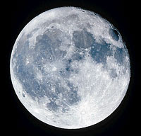
A person on Earth looking at the moon with the unaided eye can see light and dark areas on the lunar surface. The light areas are rugged, cratered highlands known as terrae (TEHR ee). The word terrae is Latin for lands. The highlands are the original crust of the moon, shattered and fragmented by the impact of meteoroids, asteroids, and comets. Many craters in the terrae exceed 25 miles (40 kilometers) in diameter. The largest is the South Pole-Aitken Basin, which is 1,550 miles (2,500 kilometers) in diameter.

The dark areas on the moon are known as maria (MAHR ee uh). The word maria is Latin for seas; its singular is mare (MAHR ee). The term comes from the smoothness of the dark areas and their resemblance to bodies of water. The maria are cratered landscapes that were partly flooded by lava when volcanoes erupted. The lava then froze, forming rock. Since that time, meteoroid impacts have created craters in the maria.

The moon has no substantial atmosphere, but small amounts of certain gases are present above the lunar surface. People sometimes refer to those gases as the lunar atmosphere. This "atmosphere" can also be called an exosphere, defined as a tenuous (low-density) zone of particles surrounding an airless body. Mercury and some asteroids also have an exosphere.

In 1959, scientists began to explore the moon with robot spacecraft. In that year, the Soviet Union sent a spacecraft called Luna 3 around the side of the moon that faces away from Earth. Luna 3 took the first photographs of that side of the moon. The word luna is Latin for moon.

On July 20, 1969, the U.S. Apollo 11 lunar module landed on the moon in the first of six Apollo landings. Astronaut Neil A. Armstrong became the first human being to set foot on the moon.

In the 1990's, two U.S. robot space probes, Clementine and Lunar Prospector, detected evidence of frozen water at both of the moon's poles. The ice came from comets that hit the moon over the last 2 billion to 3 billion years. The ice apparently has lasted in areas that are always in the shadows of crater rims. Because the ice is in the shade, where the temperature is about -400 degrees F (-240 degrees C), it has not melted and evaporated.

This article discusses Moon (The movements of the moon) (Origin and evolution of the moon) (The exosphere of the moon) (Surface features of the moon) (The interior of the moon) (History of moon study).

The movements of the moon

The moon moves in a variety of ways. For example, it rotates on its axis, an imaginary line that connects its poles. The moon also orbits Earth. Different amounts of the moon's lighted side become visible in phases because of the moon's orbit around Earth. During events called eclipses, the moon is positioned in line with Earth and the sun. A slight motion called libration enables us to see

about 59 percent of the moon's surface at different times.

Rotation and orbit

The moon rotates on its axis once every 29 1/2 days. That is the period from one sunrise to the next, as seen from the lunar surface, and so it is known as a lunar day. By contrast, Earth takes only 24 hours for one rotation.

The moon's axis of rotation, like that of Earth, is tilted. Astronomers measure axial tilt relative to a line perpendicular to the ecliptic plane, an imaginary surface through Earth's orbit around the sun. The tilt of Earth's axis is about 23.5 degrees from the perpendicular and

accounts for the seasons on Earth. But the tilt of the moon's axis is only about 1.5 degrees, so the moon has no seasons.

Another result of the smallness of the moon's tilt is that certain large peaks near the poles are always in sunlight. In addition, the floors of some craters -- particularly near the south pole -- are always in shadow.

The moon completes one orbit of Earth with respect to the stars about every 27 1/3 days, a period known as a sidereal month. But the moon revolves around Earth once with respect to the sun in about 29 1/2 days, a period known as a synodic month. A sidereal month is slightly shorter than a synodic month because, as the moon revolves around Earth, Earth is revolving around the sun. The moon needs some extra time to "catch up" with Earth. If the moon started on its orbit from a spot between Earth and the sun, it would return to almost the same place in about 29 1/2 days.

A synodic month equals a lunar day. As a result, the moon shows the same hemisphere -- the near side -- to Earth at all times. The other hemisphere -- the far side -- is always turned away from Earth.

People sometimes mistakenly use the term dark side to refer to the far side. The moon does have a dark side -- it is the hemisphere that is turned away from the sun. The location of the dark side changes constantly, moving with the terminator, the dividing line between sunlight and dark.

The lunar orbit, like the orbit of Earth, is shaped like a slightly flattened circle. The distance between the center of Earth and the moon's center varies throughout each orbit. At perigee (PEHR uh jee), when the moon is closest to Earth, that distance is 225,740 miles (363,300 kilometers). At apogee (AP uh jee), the farthest position, the distance is 251,970 miles (405,500 kilometers). The moon's orbit is elliptical (oval-shaped).

Phases

As the moon orbits Earth, an observer on Earth can see the moon appear to change shape. It seems to change from a crescent to a circle and back again. The shape looks different from one day to the next because the observer sees different parts of the moon's sunlit surface as the moon orbits Earth. The different appearances are known as the phases of the moon. The moon goes through a complete cycle of phases in a synodic month.

The moon has four phases: (1) new moon, (2) first quarter, (3) full moon, and (4) last quarter. When the moon is between the sun and Earth, its sunlit side is turned away from Earth. Astronomers call this darkened phase a new moon.

The next night after a new moon, a thin crescent of light appears along the moon's eastern edge. The remaining portion of the moon that faces Earth is faintly visible because of earthshine, sunlight reflected from Earth to the moon. Each night, an observer on Earth can see more of the sunlit side as the terminator, the line between sunlight and dark, moves westward. After about seven days, the observer can see half a full moon, commonly called a half moon. This phase is known as the first quarter because it occurs one quarter of the way through the synodic month. About seven days later, the moon is on the side of Earth opposite the sun. The entire sunlit side of the moon is now visible. This phase is called a full moon.

About seven days after a full moon, the observer again sees a half moon. This phase is the last quarter, or third quarter. After another seven days, the moon is between Earth and the sun, and another new moon occurs.

As the moon changes from new moon to full moon, and more and more of it becomes visible, it is said to be waxing. As it changes from full moon to new moon, and less and less of it can be seen, it is waning. When the moon appears smaller than a half moon, it is called crescent. When it looks larger than a half moon, but is not yet a full moon, it is called gibbous (GIHB uhs).

Like the sun, the moon rises in the east and sets in the west. As the moon progresses through its phases, it rises and sets at different times. In the new moon phase, it rises with the sun and travels close to the sun across the sky. Each successive day, the moon rises an average of about 50 minutes later.

Eclipses occur when Earth, the sun, and the moon are in a straight line, or nearly so. A lunar eclipse occurs when Earth gets directly -- or almost directly -- between the sun and the moon, and Earth's shadow falls on the moon. A lunar eclipse can occur only during a full moon. A solar eclipse occurs when the moon gets directly -- or almost directly -- between the sun and Earth, and the moon's shadow falls on Earth. A solar eclipse can occur only during a new moon.

During one part of each lunar orbit, Earth is between the sun and the moon; and, during another part of the orbit, the moon is between the sun and Earth. But in most cases, the astronomical bodies are not aligned directly enough to cause an eclipse. Instead, Earth casts its shadow into space above or below the moon, or the moon casts its shadow into space above or below Earth. The shadows extend into space in that way because the moon's orbit is tilted about 5 degrees relative to Earth's orbit around the sun.

Libration

People on Earth can sometimes see a small part of the far side of the moon. That part is visible because of lunar libration, a slight rotation of the moon as viewed from Earth. There are three kinds of libration: (1) libration in longitude, (2) diurnal (daily) libration, and (3) libration in latitude. Over time, viewers can see more than 50 percent of the moon's surface. Because of libration, about 59 percent of the lunar surface is visible from Earth.

Libration in longitude occurs because the moon's orbit is elliptical. As the moon orbits Earth, its speed varies according to a law discovered in the 1600's by the German astronomer Johannes Kepler. When the moon is relatively close to Earth, the moon travels more rapidly than its average speed. When the moon is relatively far from Earth, the moon travels more slowly than average. But the moon always rotates about its own axis at the same rate. So when the moon is traveling more rapidly than average, its rotation is too slow to keep all of the near side facing Earth. And when the moon is traveling more slowly than average, its rotation is too rapid to keep all of the near side facing Earth.

Diurnal libration is caused by a daily change in the position of an observer on Earth relative to the moon. Consider an observer who is at Earth's equator when the moon is full. As Earth rotates from west to east, the observer first sees the moon when it rises at the eastern horizon and last sees it when it sets at the western horizon. During this time, the observer's viewpoint moves about 7,900 miles (12,700 kilometers) -- the diameter of Earth -- relative to the moon. As a result, the moon appears to rotate slightly to the west.

While the moon is rising in the east and climbing to its highest point in the sky, the observer can see around the western edge of the near side. As the moon descends to the western horizon, the observer can see around the eastern edge of the near side.

Libration in latitude occurs because the moon's axis of rotation is tilted about 6 1/2 degrees relative to a line perpendicular to the moon's orbit around Earth. Thus, during each lunar orbit, the moon's north pole tilts first toward Earth, then away from Earth. When the lunar north pole is tilted toward Earth, people on Earth can see farther than normal along the top of the moon. When that pole is tilted away from Earth, people on Earth can see farther than normal along the bottom of the moon.

Origin and evolution of the moon

Scientists believe that the moon formed as a result of a collision known as the Giant Impact or the "Big Whack." According to this idea, Earth collided with a planet-sized object 4.6 billion years ago. As a result of the impact, a cloud of vaporized rock shot off Earth's surface and went into orbit around Earth. The cloud cooled and condensed into a ring of small, solid bodies, which then gathered together, forming the moon.

The rapid joining together of the small bodies released much energy as heat. Consequently, the moon melted, creating an "ocean" of magma (melted rock).

The magma ocean slowly cooled and solidified. As it cooled, dense, iron-rich materials sank deep into the moon. Those materials also cooled and solidified, forming the mantle, the layer of rock beneath the crust.

As the crust formed, asteroids bombarded it heavily, shattering and churning it. The largest impacts may have stripped off the entire crust. Some collisions were so powerful that they almost split the moon into pieces. One such collision created the South Pole-Aitken Basin, one of the largest known impact craters in the solar system.

About 4 billion to 3 billion years ago, melting occurred in the mantle, probably caused by radioactive elements deep in the moon's interior. The resulting magma erupted as dark, iron-rich lava, partly flooding the heavily cratered surface. The lava cooled and solidified into rocks known as basalts (buh SAWLTS).

Small eruptions may have continued until as recently as 1 billion years ago. Since that time, only an occasional impact by an asteroid or comet has modified the surface. Because the moon has no atmosphere to burn up meteoroids, the bombardment continues to this day. However, it has become much less intense.

Impacts of large objects can create craters. Impacts of micrometeoroids (tiny meteoroids) grind the surface rocks into a fine, dusty powder known as the regolith (REHG uh lihth). Regolith overlies all the bedrock on the moon. Because regolith forms as a result of exposure to space, the longer a rock is exposed, the thicker the regolith that forms on it.

The exosphere of the moon

The lunar exosphere -- that is, the materials surrounding the moon that make up the lunar "atmosphere" -- consists mainly of gases that arrive as the solar wind. The solar wind is a continuous flow of gases from the sun -- mostly hydrogen and helium, along with some neon and argon.

The remainder of the gases in the exosphere form on the moon. A continual "rain" of micrometeoroids heats lunar rocks, melting and vaporizing their surface. The most common atoms in the vapor are atoms of sodium and potassium. Those elements are present in tiny amounts -- only a few hundred atoms of each per cubic centimeter of exosphere. In addition to vapors produced by impacts, the moon also releases some gases from its interior.

Most gases of the exosphere concentrate about halfway between the equator and the poles, and they are most plentiful just before sunrise. The solar wind continuously sweeps vapor into space, but the vapor is continuously replaced.

During the night, the pressure of gases at the lunar surface is about 3.9 x 10⁻¹⁴

pound per square inch (2.7 x 10⁻¹⁰ pascal). That is a stronger vacuum than laboratories on Earth can usually achieve. The exosphere is so tenuous -- that is, so low in density -- that the rocket exhaust released during each Apollo landing temporarily doubled the total mass of the entire exosphere.

The surface of the moon is covered with bowl-shaped holes called craters, shallow depressions called basins, and broad, flat plains known as maria. A powdery dust called the regolith overlies much of the surface of the moon.

Craters

The vast majority of the moon's craters are formed by the impact of meteoroids, asteroids, and comets. Craters on the moon are named for famous scientists. For example, Copernicus Crater is named for Nicolaus Copernicus, a Polish astronomer who realized in the 1500's that the planets move about the sun. Archimedes Crater is named for the Greek mathematician Archimedes, who made many mathematical discoveries in the 200's B.C.

The shape of craters varies with their size. Small craters with diameters of less than 6 miles (10 kilometers) have relatively simple bowl shapes. Slightly larger craters cannot maintain a bowl shape because the crater wall is too steep. Material falls inward from the wall to the floor. As a result, the walls become scalloped and the floor becomes flat.

Still larger craters have terraced walls and central peaks. Terraces inside the rim descend like stairsteps to the floor. The same process that creates wall scalloping is responsible for terraces. The central peaks almost certainly form as did the central peaks of impact craters on Earth. Studies of the peaks on Earth show that they result from a deformation of the ground. The impact compresses the ground, which then rebounds, creating the peaks. Material in the central peaks of lunar craters may come from depths as great as 12 miles (19 kilometers).

Surrounding the craters is rough, mountainous material -- crushed and broken rocks that were ripped out of the crater cavity by shock pressure. This material, called the crater ejecta blanket, can extend about 60 miles (100 kilometers) from the crater.

Farther out are patches of debris and, in many cases, irregular secondary craters, also known as secondaries. Those craters come in a range of shapes and sizes, and they are often clustered in groups or aligned in rows. Secondaries form when material thrown out of the primary (original) crater strikes the surface. This material consists of large blocks, clumps of loosely joined rocks, and fine sprays of ground-up rock. The material may travel thousands of miles or kilometers.

Crater rays are light, wispy deposits of powder that can extend thousands of miles or kilometers from the crater. Rays slowly vanish as micrometeoroid bombardment mixes the powder into the upper surface layer. Thus, craters that still have visible rays must be among the youngest craters on the moon.

Craters larger than about 120 miles (200 kilometers) across tend to have central mountains. Some of them also have inner rings of peaks, in addition to the central peak. The appearance of a ring signals the next major transition in crater shape -- from crater to basin.

Basins are craters that are 190 miles (300 kilometers) or more across. The smaller basins have only a single inner ring of peaks, but the larger ones typically have multiple rings. The rings are concentric -- that is, they all have the same center, like the rings of a dartboard. The spectacular, multiple-ringed basin called the Eastern Sea (Mare Orientale) is almost 600 miles (1,000 kilometers) across. Other basins can be more than 1,200 miles (2,000 kilometers) in diameter -- as large as the entire western United States.

Basins occur equally on the near side and far side. Most basins have little or no fill of basalt, particularly those on the far side. The difference in filling may be related to variations in the thickness of the crust. The far side has a thicker crust, so it is more difficult for molten rock to reach the surface there.

In the highlands, the overlying ejecta blankets of the basins make up most of the upper few miles or kilometers of material. Much of this material is a large, thick layer of shattered and crushed rock known as breccia (BREHCH ee uh). Scientists can learn about the original crust by studying tiny fragments of breccia.

Maria, the dark areas on the surface of the moon, make up about 16 percent of the surface area. Some maria are named in Latin for weather terms -- for example, Mare Imbrium (Sea of Rains) and Mare Nubium (Sea of Clouds). Others are named for states of mind, as in Mare Serenitatus (Sea of Serenity) and Mare Tranquillitatis (Sea of Tranquility).

Landforms on the maria tend to be smaller than those of the highlands. The small size of mare features relates to the scale of the processes that formed them -- volcanic eruptions and crustal deformation, rather than large impacts. The chief landforms on the maria include wrinkle ridges and rilles and other volcanic features.

Wrinkle ridges are blisterlike humps that wind across the surface of almost all maria. The ridges are actually broad folds in the rocks, created by compression. Many wrinkle ridges are roughly circular, aligned with small peaks that stick up through the maria and outlining interior rings. Circular ridge systems also outline buried features, such as rims of craters that existed before the maria formed.

Rilles are snakelike depressions that wind across many areas of the maria. Scientists formerly thought the rilles might be ancient riverbeds. However, they now suspect that the rilles are channels formed by running lava. One piece of evidence favoring this view is the dryness of rock samples brought to Earth by Apollo astronauts; the samples have almost no water in their molecular structure. In addition, detailed photographs show that the rilles are shaped somewhat like channels created by flowing lava on Earth.

Volcanic features

Scattered throughout the maria are a variety of other features formed by volcanic eruptions. Within Mare Imbrium, scarps (lines of cliffs) wind their way across the surface. The scarps are lava flow fronts, places where lava solidified, enabling lava that was still molten to pile up behind them. The presence of the scarps is one piece of evidence indicating that the maria consist of solidified basaltic lava.

Small hills and domes with pits on top are probably little volcanoes. Both dome-shaped and cone-shaped volcanoes cluster together in many places, as on Earth. One of the largest concentrations of cones on the moon is the Marius Hills complex in Oceanus Procellarum (Ocean of Storms). Within this complex are numerous wrinkle ridges and rilles, and more than 50 volcanoes.

Large areas of maria and terrae are covered by dark material known as dark mantle deposits. Evidence collected by the Apollo missions confirmed that dark mantling is volcanic ash.

Much smaller dark mantles are associated with small craters that lie on the fractured floors of large craters. Those mantles may be cinder cones -- low, broad, cone-shaped hills formed by explosive volcanic eruptions.

The interior of the moon

The moon, like Earth, has three interior zones -- crust, mantle, and core. However, the composition, structure, and origin of the zones on the moon are much different from those on Earth.

Most of what scientists know about the interior of Earth and the moon has been learned by studying seismic events -- earthquakes and moonquakes, respectively. The data on moonquakes come from scientific equipment set up by Apollo astronauts from 1969 to 1972.

Crust

The average thickness of the lunar crust is about 43 miles (70 kilometers), compared with about 6 miles (10 kilometers) for Earth's crust. The outermost part of the moon's crust is broken, fractured, and jumbled as a result of the large impacts it has endured. This shattered zone gives way to intact material below a depth of about 6 miles. The bottom of the crust is defined by an abrupt increase in rock density at a depth of about 37 miles (60 kilometers) on the near side and about 50 miles (80 kilometers) on the far side.

Mantle

The mantle of the moon consists of dense rocks that are rich in iron and magnesium. The mantle formed during the period of global melting. Low-density minerals floated to the outer layers of the moon, while dense minerals sank deeper into it.

Later, the mantle partly melted due to a build-up of heat in the deep interior. The source of the heat was probably the decay (breakup) of uranium and other radioactive elements. This melting produced basaltic magmas -- bodies of molten rock. The magmas later made their way to the surface and erupted as the mare lavas and ashes. Although mare volcanism occurred for more than 1 billion years -- from at least 4 billion years to fewer than 3 billion years ago -- much less than 1 percent of the volume of the mantle ever remelted.

Core

Data gathered by Lunar Prospector confirmed that the moon has a core and enabled scientists to estimate its size. The core has a radius of only about 250 miles (400 kilometers). By contrast, the radius of Earth's core is about 2,200 miles (3,500 kilometers).

The lunar core has less than 1 percent of the mass of the moon. Scientists suspect that the core consists mostly of iron, and it may also contain large amounts of sulfur and other elements.

Earth's core is made mostly of molten iron and nickel. This rapidly rotating molten core is responsible for Earth's magnetic field. A magnetic field is an influence that a magnetic object creates in the region around it. If the core of a planet or a satellite is molten, motion within the core caused by the rotation of the planet or satellite makes the core magnetic. But the small, partly molten core of the moon cannot generate a global magnetic field. However, small regions on the lunar surface are magnetic. Scientists are not sure how these regions acquired magnetism. Perhaps the moon once had a larger, more molten core.

There is evidence that the lunar interior formerly contained gas, and that some gas may still be there. Basalt from the moon contains holes called vesicles that are created during a volcanic eruption. On Earth, gas that is dissolved in magma comes out of solution during an eruption, much as carbon dioxide comes out of a carbonated beverage when you shake the drink container. The presence of vesicles in lunar basalt indicates that the deep interior contained gases, probably carbon monoxide or gaseous sulfur. The existence of volcanic ash is further evidence of interior gas; on Earth, volcanic eruptions are largely driven by gas.

History of moon study

Ancient ideas

Some ancient peoples believed that the moon was a rotating bowl of fire. Others thought it was a mirror that reflected Earth's lands and seas. But philosophers in ancient Greece understood that the moon is a sphere in orbit around Earth. They also knew that moonlight is reflected sunlight.

Some Greek philosophers believed that the moon was a world much like Earth. In about A.D. 100, Plutarch even suggested that people lived on the moon. The Greeks also apparently believed that the dark areas of the moon were seas, while the bright regions were land.

In about A.D. 150, Ptolemy, a Greek astronomer who lived in Alexandria, Egypt, said that the moon was Earth's nearest neighbor in space. He thought that both the moon and the sun orbited Earth. Ptolemy's views survived for more than 1,300 years. But by the early 1500's, the Polish astronomer Nicolaus Copernicus had developed the correct view -- Earth and the other planets revolve about the sun, and the moon orbits Earth.

Early observations with telescopes

The Italian astronomer and physicist Galileo wrote the first scientific description of the moon based on observations with a telescope. In 1609, Galileo described a rough, mountainous surface. This description was quite different from what was commonly believed -- that the moon was smooth. Galileo noted that the light regions were rough and hilly and the dark regions were smoother plains.

The presence of high mountains on the moon fascinated Galileo. His detailed description of a large crater in the central highlands -- probably Albategnius -- began 350 years of controversy and debate about the origin of the "holes" on the moon.

Other astronomers of the 1600's mapped and cataloged every surface feature they could see. Increasingly powerful telescopes led to more detailed records. In 1645, the Dutch engineer and astronomer Michael Florent van Langren, also known as Langrenus, published a map that gave names to the surface features of the moon, mostly its craters. A map drawn by the Bohemian-born Italian astronomer Anton M. S. de Rheita in 1645 correctly depicted the bright ray systems of the craters Tycho and Copernicus. Another effort, by the Polish astronomer Johannes Hevelius in 1647, included the moon's libration zones.

By 1651, two Jesuit scholars from Italy, the astronomer Giovanni Battista Riccioli and the mathematician and physicist Francesco M. Grimaldi, had completed a map of the moon. That map established the naming system for lunar features that is still in use.

Determining the origin of craters

Until the late 1800's, most astronomers thought that volcanism formed the craters of the moon. However, in the 1870's, the English astronomer Richard A. Proctor proposed correctly that the craters result from the collision of solid objects with the moon. But at first, few scientists accepted Proctor's proposal. Most astronomers thought that the moon's craters must be volcanic in origin because no one had yet described a crater on Earth as an impact crater, but scientists had found dozens of obviously volcanic craters.

In 1892, the American geologist Grove Karl Gilbert argued that most lunar craters were impact craters. He based his arguments on the large size of some of the craters. Those included the basins, which he was the first to recognize as huge craters. Gilbert also noted that lunar craters have only the most general resemblance to calderas (large volcanic craters) on Earth. Both lunar craters and calderas are large circular pits, but their structural details do not resemble each other in any way.

In addition, Gilbert created small craters experimentally. He studied what happened when he dropped clay balls and shot bullets into clay and sand targets.

Gilbert was the first to recognize that the circular Mare Imbrium was the site of a gigantic impact. By examining photographs, Gilbert also determined which nearby craters formed before and after that event. For example, a crater that is partially covered by ejecta from the Imbrium impact formed before the impact. A crater within the mare formed after the impact.

Describing lunar evolution

Gilbert suggested that scientists could determine the relative age of surface features by studying the ejecta of the Imbrium impact. That suggestion was the key to unraveling the history of the moon. Gilbert recognized that the moon is a complex body that was built up by innumerable impacts over a long period.

In his book The Face of the Moon (1949), the American astronomer and physicist Ralph B. Baldwin further described lunar evolution. He noted the similarity in form between craters on the moon and bomb craters created during World War II (1939-1945) and concluded that lunar craters form by impact.

Baldwin did not say that every lunar feature originated with an impact. He stated correctly that the maria are solidified flows of basalt lava, similar to flood lava plateaus on Earth. Finally, independently of Gilbert, he concluded that all circular maria are actually huge impact craters that later filled with lava.

In the 1950's, the American chemist Harold C. Urey offered a contrasting view of lunar history. Urey said that, because the moon appears to be cold and rigid, it has always been so. He then stated -- correctly -- that craters are of impact origin. However, he concluded falsely that the maria are blankets of debris scattered by the impacts that created the basins. And he was mistaken in concluding that the moon never melted to any significant extent. Urey had won the 1934 Nobel Prize in chemistry and had an outstanding scientific reputation, so many people took his views seriously. Urey strongly favored making the moon a focus of scientific study. Although some of his ideas were mistaken, his support of moon study was a major factor in making the moon an early goal of the U.S. space program.

In 1961, the U.S. geologist Eugene M. Shoemaker founded the Branch of Astrogeology of the U.S. Geological Survey (USGS). Astrogeology is the study of celestial objects other than Earth. Shoemaker showed that the moon's surface could be studied from a geological perspective by recognizing a sequence of relative ages of rock units near the crater Copernicus on the near side. Shoemaker also studied the Meteor Crater in Arizona and documented the impact origin of this feature. In preparation for the Apollo missions to the moon, the USGS began to map the geology of the moon using telescopes and pictures. This work gave scientists their basic understanding of lunar evolution.

Apollo missions

Beginning in 1959, the Soviet Union and the United States sent a series of robot spacecraft to examine the moon in detail. Their ultimate goal was to land people safely on the moon. The United States finally reached that goal in 1969 with the landing of the Apollo 11 lunar module. The United States conducted six more Apollo missions, including five landings. The last of those was Apollo 17, in December 1972.

The Apollo missions revolutionized the understanding of the moon. Much of the knowledge gained about the moon also applies to Earth and the other inner planets -- Mercury, Venus, and Mars. Scientists learned, for example, that impact is a fundamental geological process operating on the planets and their satellites.

After the Apollo missions, the Soviets sent four Luna robot craft to the moon. The last, Luna 24, returned samples of lunar soil to Earth in August 1976.

Recent exploration

No more spacecraft went to the moon until January 1994, when the United States sent the orbiter Clementine. From February to May of that year, Clementine's four cameras took more than 2 million pictures of the moon. A laser device measured the height and depth of mountains, craters, and other features. Radar signals that Clementine bounced off the moon provided evidence of a large deposit of frozen water. The ice appeared to be inside craters at the south pole.

The U.S. probe Lunar Prospector orbited the moon from January 1998 to July 1999. The craft mapped the concentrations of chemical elements in the moon, surveyed the moon's magnetic fields, and found strong evidence of ice at both poles. Small particles of ice are apparently part of the regolith at the poles.

The SMART-1 spacecraft, launched by the European Space Agency in 2003, went into orbit around the moon in 2004. The craft's instruments were designed to investigate the moon's origin and conduct a detailed survey of the chemical elements on the lunar surface.

Contributor: Paul D. Spudis, Ph.D., Deputy Director and Staff Scientist, Lunar and Planetary Institute.